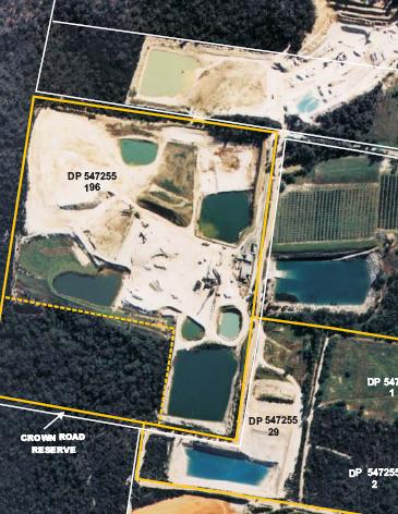
Lot 196, Maroota, 2007, from Statement of Environmental Effects at pp14-15, for Dixon Sands.
Date: 15th
February 2008,
by email, by hand
To:
NSW Department of Planning, Major Projects (DOP)
Ground Floor, 23-33 Bridge St Sydney
NSW 2000
Attn:
Michael Young, Dept of Planning
CC: Minister Koperberg, Dept of Energy & Water
Dear Sir
Objection
to modification – Old Northern Road Quarry (DA
250-9-01 MOD2) by Neville Diamond and Thomas McLoughlin
This submission is by Thomas McLoughlin as editor of www.sydneyalternativemedia.com, principal of ecology action Australia
(unincorporated), and a solicitor in NSW, in his own capacity.
It is also a submission jointly and severally for Neville Diamond by Tom
McLoughlin as his solicitor on a strictly pro bono basis in the public interest
regarding ecological sustainability and due process.
The history of litigation by Neville Diamond while working for and/or in association with Dixon Sands (Penrith) Pty
Ltd is outlined at Appendix A1.
Disclaimer: Neither Tom
McLoughlin, nor any organisation he has worked for, or been a member of, has ever received any financial or in kind benefit
or promise of benefit in a financial sense, in relation to sand mining at Maroota or anywhere, or in relation to Neville Diamond
except to say trivial secretarial disbursements of tens of dollars. This statement is made as a legal practitioner in NSW
and applies for all of the 1990ies to the present time.
Formality concerns
with notification
#1
The objector Diamond has been notified of a modification by letter of the Dept of Planning (DOP) dated 25th January
2008 “under “section 96AA of the Environmental Planning and Assessment Act 1979” (EPAA).
Refer appendix A.
However the Statement of Environment Effects (“SEE”)
of Dixon Sands (Penrith) Pty Ltd ( “DS”) refers at page 3:
2.1 STATUTORY PROCEDURES AND APPROVAL PROCESS
In order to amend the development consent (DA
250-09-01) to increase the
number of truck movements at the quarry there
are certain procedures
specified in Section 96 of the Environmental Planning and Assessment Act,
1979
(EP&A Act). Under Section 96(1A) of this Act the consent authority, in this
case the Minister for Infrastructure and Planning
can agree to modify the
development consent if: [bold added]
We are not sure if anything turns on this incorrect
(?) reference in the EPAA by the DS SEE.
#2
The SEE refers at page 2
PROPOSED MODIFICATION
Two modifications are requested to the conditions
of development consent
DA 250-09-01. Consent conditions 3.30 and 3.31
are requested to be modified
in the following manner:
Existing Condition 3.30
Traffic and Transport Impacts – Total vehicle
movements at the site, including
those provided for in consents 796/00/HE, 250-9-01 and 165-7-2005, shall not
exceed a combined total of 88 laden movements
per day or 120 vehicle
movements per day.
Modified Condition 3.30
Traffic and Transport Impacts – Total vehicle
movements at the site, including
those provided for in consents 796/00/HE, 250-09-01 and 165-7-2005, shall
not exceed a combined total of 180 vehicle movements
per day.
We note that modification of the “2004 consent”
for DA 250-9-01
(full
reference Diamond v Minister for Planning New South Wales and Another (No
2) [2004] NSWLEC 254 PARTIES :APPLICANT Neville Diamond/
FIRST RESPONDENT Minister for Planning New South Wales /SECOND RESPONDENT/ Dixon Sand (Penrith) Pty Ltd/ FILE NUMBER(S) :10206 of 2003 CORAM:Talbot J”)
has been duly notified by the DOP but the proposed
modifications as described in the DS SEE includes changes to two other consents
not in the notice of the DOP of 25 Jan 2008.
This may well be ground for re notification to
objectors of those other consents.
Threshhold
legal submission DS are unlicensed, have not legally commenced ‘2004 consent’, lapsed ‘2000 consent’
Our submission is that the 24 May 2004 (250-09-01) consent (“the 2004 consent”) via the Land & Environment Court to Dixon Sands (Penrith) Pty
Ltd (DS) has not ever been lawfully licensed (as demonstrated below by reference to expert evidence of Donges 1984 and 1989) prior to commencement of work for lack of:
- licensing
under the Water Act 1912 NSW Part 5 (WA) for the
excavation in groundwater for the main storage pond on Lot 196, and
- licence
for pumping from main storage pond, and
- licence
for any other (eg portable) water pump(s) drawing of water (i.e. distinct from the bores that are licensed) including water
used for dust suppression
which licenses were never obtained.
We submit that implicit in the 2004 consent conditions
is that all lawful required licenses would be obtained prior to commencement.
Additionally and/or alternatively we submit that
by clause 1.12 in the 2004 consent “Dispute Resolution” which reads:
Dispute Resolution
l.12 In the
event that a dispute arises between the Applicant and a public authority other than the Department, in relation to a specification
or requirement applicable under this consent, the Applicant shall refer the matter to the Director-General, and if not resolved,
to the Minister, whose determination of the dispute shall be final and binding on all parties. For the purpose of this condition,
"public authority" has the same meaning as provided under section 4 of the Act.
logically applies whereby the failure to obtain
licenses should be referred to the Director General (DG) of DOP and the Minister of Planning because our submission is being
made contemporaneously to the Minister for the Dept of Water & Energy (“DWE”) on the same basis of ongoing
illegal unlicensed use of water, and breach of RFIA, for which DWE are duty bound to act upon given our notice by this submission.
(See also Appendix B regarding allegations
of corruption by objector Neville Diamond dated 23 January 2008 in this respect, submitted to Minister Koperberg responsible
for DWE – submitted to DWE?DOP but otherwise not published.)
In other words we submit the evidence (below)
raises a constructive conflict between ‘another public authority’ (DWE)
as per cl 1.12 above and DS over extended years of illegal unlicensed water use, and illegal unlicensed breach of the Rivers and Foreshores Improvement Act 1948 NSW (“RFIA”).
We submit it is not open to the DOP DG or DOP
Minister (despite the assertions of finality over conflict resolution endorsed by Justice Talbot in the 2004 consent as per
cl 1.12 above) to ex post facto facilitate ongoing illegality contrary to the Water Act 1912. This is a matter of separation of powers and supremacy of the Parliament
over judicial decision making.
Indeed any person who facilitates ongoing illegality
may well be guilty of an offence under the Water Act 1912 and subject to prosecution.
Including the DG or Minister and we assume the Minister does not seek to go down that track. In any case we submit strongly
that the neither the DG or the Minister for DOP should be in the business of rewarding illegality with an ongoing consent
to modify, nor will it resolve a complaint to the DWE over failure to license extraction in groundwater, or breach of RFIA.
In this respect we strongly submit that this is contrary “to the public interest” as per EPAA S.79C re evaluation.
The full 2004 consent is found here:
http://www.lawlink.nsw.gov.au/lecjudgments/2004nswlec.nsf/d1efd3b3c2f68e05ca256736001f37be/117a2f806592bd91ca256e9a001dc1bf?OpenDocument
and via DS website
http://www.dixonsand.com.au/legal_frame.htm
…………………………
We also question whether the 2004 consent has even legally commenced in the absence of the required licensing. It is well established authority that works
done unlawfully (as demonstrated below) cannot count as commencement
“….work done unlawfully under
the consent cannot count as commencement to prevent the lapsing of a consent under s.99 …” : Coalcliff Community Association Inc v Minister for Urban Affairs and Planning (1999) 106 LGERA 243 at 263, per
Stein JA.
Given use of the unlicensed main water storage
as evidenced below is central to the whole operation of DS in its entirety it may be that the whole DS sand mine on Lot 196 has been tainted with illegality from the outset and failed to commence.
We submit it follows that for a development that
has not lawfully commenced in full or part it is highly inappropriate for the DOP to provide any consent to modify.
………………………..
Similarly we note by the notice of determination
dated 2nd March 2000 from Michael Watt Director - Planning Services, Baulkham Hills Shire Council (BHSC) for DA
No. 796/00/HE – Lot 29/196 (“the 2000 consent”) at p11
“2.29 The proponent is to obtain all
necessary operating licences and permits from all relevant public authorities including the Environment Protection Authority
and the Department of Land & Water Conservation and details of which are to be submitted to Council prior to the commencement of on-site works.”
Similarly we submit that the 2000 consent has
not lawfully commenced for lack of prior licences and permits and, further that
the consent is even lapsed and out of time by operation of the Environmental Planning
& Assessment Act 1979 NSW (EPAA):
“s.95(1) A development lapses 5 years
after the date from which it operates.”
Our
evidence of failure to obtain (groundwater) licenses for Lot 196 sand mining operation
Our evidence relates to lack of licensing under
the Water Act 1912 NSW Part 5 (“Water Act) for the excavation in groundwater
for the main storage pond on Lot 196, and licence for pumping from main storage pond, and licence for any other (eg portable)
water pump(s) draw water (i.e. distinct from the bores that are licensed) including water used for dust suppression which
were never obtained.
Ken Dixon as patriarch of DS vaguely acknowledged
this state of affairs in the 1999 litigation between DS v Baulkham Hills Shire Council case no. 40130/98 & 10757/98 before
Lloyd J as follows (extract Appendix C):
Q.
[Counsel] Mr Dixon, I gather the company’s records would not allow us to tell
what proportion of the water is ground water and what propotion is rain water?
A.
No, it would not.
B.
And you wouldn’t know – no testing or no assessment’s been made of that to your knowledge?
A.
No.
In other words Ken Dixon does not contradict groundwater
is in use but does not know to what degree. Nor would he want to know in case of the high degree of controversy that might
lead to given the Maroota Groundwater Study underway since at least 1996 (as referred below) which might draw interest of
public authorities to his sand mining operation.
So much for commercial discretion by Ken Dixon
for DS: As we understand this covert attitude relates to the original excavation on Lot 196
in the 1980ies was on pretext of a “farm dam” thus avoiding Water Act 1912 licensing requirements. As so often
seems to happen these “farm dams” are a cover for unlicensed sand mining extractive industry.
We can demonstrate that in fact DS had corporate
knowledge as per their 1999 EIS
(full name “Dixon Sands (Penrith) Pty Ltd/ Extraction, Rehabilitation and processing of construction sands, Lots 196 and 29, DP
752025 North Maroota, NSW/ Southern Environmental Pty Ltd/ 15th February 1999 ”
referred to as the “1999 EIS”)
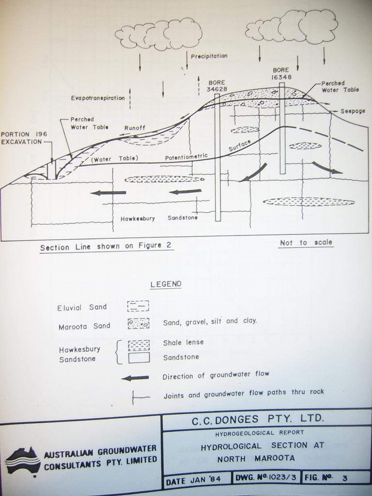
of the intersection of the groundwater in the
“perched water table” as shown by Donges by Figure 3 in the “1984
EIS”
(full name
“PF Formation/ Environmental Impact Statement/ Dam construction/ Portion
196 Old Northern Rd Maroota/ Collin C. Donges & Associates Pty. Limited/ February 1984”) .
The 1984 Donges Figure 3 perched water table at
Lot 196 is at Appendix D. This Donges historical baseline data informs all the following
environmental assessment documents re intersection of the groundwater including the current SEE.
This intersection of the ground water remains
the reality despite assurances to the contrary in the 1999 EIS technical papers Appendix
C5 – Groundwater Impact Assessment quoting Lyall & Macoun Consulting
Engineers states
“There is reported to be a spring that
flowed in the existing tailings pond, the original depth of which is unknown. The current bottom level is approximately 170m
AHD, well above the likely level of groundwater at 160 AHD plus. It is therefore expected that th excavation (by the previous
operator) could have intersected the aquifer, but the resultant tailings placement (by Dixon Sand) would have now sealed the
flow.
There are no other excavations on the site
that are below 160m AHD.
The main storage dam has a current bed level
of approximately 161m AHD. This dam is part of the original excavation on the site, carried out in the 1980s. The standing
water level in DS No1 is 158m AHD, and is located immediately alongside this storage.”
[and refer extract at our Appendix H
of the 1999 EIS.]
On the contrary, in the 1984 EIS Donges at Figure
3 (refer appendix D) shows the perched water table clearly breached by
the excavation on 196. Further there is no way of saying vaguely in the 1999 EIS that tailings have “sealed” a
breach of the water table. The clay fines are not water impermeable and we find this claim of the breach having been sealed
as unproven and contrary to the precautionary principle. Also deceptive and misleading.
For instance gain in the “1989 EIS”
(full name “PF Formation/ Environmental
Impact Statement Extension of Existing Extractive Industry Portion 196 Old Northern Road Maroota/ Collin C Donges & Associates
Pty Limited/ exhibition period 22/5/89 – 22/6/89)
there are constant references to the intrusion
into the groundwater on Lot 196 and surface springs in the area. Refer our extract at
Appendix E. We specifically refer to p14
“Portion 196 is in a topographical
low area and in the discharge zone of the regional groundwater flow through the
Hawkesbury Sandstone aquifer and of flow in the perched aquifers formed by the deep weathering of this sandstone.
Groundwater
springs are observed in creeks on the property and the area was originally swampy
before the drainage occurred by the present excavation activities. Due to the wetness of the area the soils contain organic materials and clays, from chemical decomposition of feldspars in the sandstone, which is in contrast to the leached white sand soils further up the gradient
and above the water table.”
[bold added]
Indeed Figure 8 (at Appendix F) used by
Donges in the 1989 EIS is very similar to Figure 3 in 1984 describing the perched water table.
We submit other indirect but still quite scientific
evidence of unlicensed (WA) breach of the groundwater by the main storage pond will also be available: Breach of the perched
aquifer can be tested and very likely will be verified by the calculation and reconciliation of the water usage involved in
operating the sand mine on Lot 196 namely
(a) pumping
from the bores,
(b) pumping
from clean water pond
(c) pumping
from any other water sources onsite
(d) evaporation
losses from surface of the dam, stockpiles, land surface,
(e) water
needed for dust suppression
(f)
export of water offsite in the sand product (at around 10% industry standard)
(g) as
well as any surface water captured and used.
This calculation/information should be available
for the water license(s) that have been obtained by DS for their bores.
We understand DS is licensed to use 60 MegaLitres
but that processing of up to 495K tonnes of sand per annum strongly implies water usage of approximately 300 ML in gross exceedance
of their bore license(s): This is by way of comparison with the ERM McCotter 1998 expert report into water usage of PF Formation
at Trig Hill Area of 332 ML water usage p.a.. for 400K tonne sand per annum extracted. The ERM McCotter report on PF is at
Appendix G for comparison.
DS and PF have similar sized sand washing facilities
at Maroota but PF’s feedstock is of a lower quality to DS feedstock.
It becomes quite apparent where this extra unlicensed
water is coming from – the groundwater inflow into the main storage pond via intersection with the groundwater –
which therefore must be licensed under the Water Act 1912. Thus the whole house of cards and subterfuge is exposed by the
historical Donges EIS 1984 and 1989.
In light of the compelling Donges historical evidence in the 1984 and 1989 EIS via the evidence of both Connors and McKibbon in the 2004
consent litigation is similarly unsafe as to use/non use and intersection of groundwater on Lot 196:
Talbot J found on the limited evidence presented
to him at that time:
Ground Water
57
Dan McKibbin is a Senior Natural Resource Officer (Senior Hydrogeologist) within the Sydney/South Coast Region of DIPNR. Mr
McKibbin has been involved with groundwater resource matters for the Maroota Extractive Industry area since 1996. His evidence
addresses groundwater resource management issues in respect to the Dixon
Sand operations on lot 196. Mr McKibbin has visited and surveyed the site several times since 1996.
58 He says that
the operational dams on the Dixon Sand site have not intersected
the permanent water table level of the Hawkesbury Sandstone Aquifer. On the basis of the drillers completion record of a new
monitoring bore constructed in February this year, he is of the opinion that no groundwater was intersected in the fresh sandstone
to a depth of 10 metres.
59 There is a much deeper groundwater system in the Hawkesbury Sandstone that occurs below
about 35 metres. It appears to Mr McKibbin that the water levels in the new bore are an artefact of the presence of the stored
waters in the main storage pond, and the disturbed nature of the ground. In his opinion, therefore, the operational dams on
Dixon Sands north Maroota site do not require licensing under
the Water Act.
60 When it was put to him in cross examination that a blue colour in water is an indication of the presence
of groundwater he replied that blue coloration of the water is a matter of the light reflection and that blue water is not
necessarily groundwater.
61 Mr Kitto says that the groundwater monitoring regime proposed would involve monitoring
groundwater levels monthly and quality levels every six months with the results published in an annual report and an independent
audit taken every three or four years. In addition, spot checks would occur when the department’s officers were in the
area or in response to complaints.
62 Mr Conners undertook an inspection of the site on 20 January 2004, which confirmed
the existence of five monitoring bores and two production boors on the site as licensed.
63 As I have already said,
in his opinion, all works intercepting groundwater on the site have been correctly licensed.
Water
Licenses
64
In cross-examination, Mr Conners states that he is responsible for the approvals of groundwater and surface water licenses,
including renewals and the issue of such licenses. He also has a role in liaising with senior management and preparing cases
for objections received. When asked by Mr Diamond whether a system was in place to monitor the illegal use of water in the
sand mining precinct at Maroota, Mr Conners told the Court that DIPNR renews licenses every five years, they respond to community
complaints and concerns and “do their best” to follow those up
as quickly as possible. He says that at present there are 13,000 licenses in the Sydney/South Coast Region and “there just isn’t the resource to be able to inspect these at renewal”. Mr Kitto nevertheless
expressed confidence that the water licensing section of DIPNR has sufficient resources to “properly manage and run licensing, detection and monitoring in the Maroota sand mining precinct” [
65
In relation to complaints about unlicensed work involving surface water or groundwater, Mr Conners says that there is a compliance
unit in every region and his department is now required to liaise with that compliance unit in relation to complicated complaints.
In the first instance a water licensing officer would investigate that complaint and make a report.
We submit the compelling Donges evidence re intersection
with the groundwater on Lot 196 is a damning contradiction of the evidence of McKibbon and
Connors as to so called ‘no groundwater use’. Indeed we feel the Court and his honour Talbot J was badly misled.
Word games about permanent, or deep, versus perched or shallow aquifers, appear to have been played out but the law under
the Water Act 1912 Part 5 is quite clear that
groundwater use must be licensed regardless.
(We find this deception highly resonating with
the parallel phenomenon of the way the sand miner developer’s expert Carosone expert evidence was recently demonstrated
by us re Trig Hill Area to mislead the stakeholders at Maroota as to the high degree of groundwater loss on the Trig Hill
Area to the Taylor property, resulting from the PF Formation operations there: Regretably Carosene was refuted out of time
by the Sullivan expert report in that situation, as per our submission to DOP January 31st 2008.)
Regretably the 1984 and 1989 EIS expert evidence
was not available in the 2003-4 litigation because plaintiff Diamond was legally unrepresented and didn’t have the material
to hand in a timely way. However it is wrong to say Diamond was the only concerned citizen at the draw down of groundwater
of Lot 196. We are advised that in 2002-2003 the East Bend Community Group/Pat Swartz (patron
Kevin Rozolli former NSW MP) wrote to DIPNR as forerunner of DOP, also greatly concerned about impact on groundwater at Lot 196.
Our
evidence of lack of licensing under the Rivers & Foreshores Improvement Act 1948
NSW (RFIA)
Similar to lack of water licensing we also challenge
DS to produce permit(s) with diagrams/supporting documentation under the RFIA allowing them to breach the 40 metre buffer
zone of any creek on Lot 196.
The DS EIS 1999 Figure 3.1, 3.2, 3.3 (see appendix
H) shows that creek lines described 1984 and 1989 (sourced from Donges for PF) then vandalised by 1999, have been destroyed
in the last 24 years of the sand mining operation. Figure 3.1 of the current DS SEE August 2007 (shown above page 1, and below
) reinforces the greater vandalism of the creek line.
We understand part of the creek line destruction
may/may not have received a permit under the RFIA in Fig 3.1 as “appropriate position of watercourse” but that
no RFIA ‘3A permit’ has been obtained for the weir originally made of sand/cement bags which was later cemented
over by Ken Dixon in the late 1990ies, under instructions by Baulkham Hills Shire Council (BHSC). We submit that DS complied
with the demand of BHSC concern to fix a leak in the weir but that BHSC otherwise took no interest in the RFIA permit requirement
which remained the legal obligation of DS to obtain. We understand there is no
RFIA permit to the present. If there is we call on DS to produce the license and publish it on their website as per the 2004
consent.
However no RFIA permit is presented as required
by the 2004 consent on the DS website that we can identify at this stage.
Lack
of DS website notification of licenses required for Lot 196 under 2004 consent
On the basis that these water and RFIA licenses
are lawfully required we note the following highly suggestive situation:
As we understand as of 14th February
the DS website lists at the “LEGAL” subheading at web address:
http://www.dixonsand.com.au/legal_frame.htm
the following:
Old Northern Road Quarry - Lots
196 & 29
·
EPA Licence No.3916 [link]
·
Development Consent 796-00-HE [pdf] (3.2mb)
Old Northern Road Quarry - Lots 1 & 2 extension
·
EPA Licence No.3916 [link]
·
Site Environmental Management Plan [pdf] (12mb)
·
Final Court Judgement and Development
Consent 250-09-01 [link]
·
2006 Notice of Modification to Consent Conditions
[link]
In the “2004 Consent”
by clause 1.11
1.11 Subject to commercial confidentiality
the Applicant shall make the following documents available to the public upon request at the quarry site and Council, and
shall post all documents on the internet, within 14 days of approval of the documents
by the Director-General or relevant agency:
a) this consent and the existing consent;
b) any licences or approvals for the quarry obtained from Government agencies; and
c) all documents required under this consent, including environmental management plans, AEMR’s, and Independent
Audits.
The Applicant shall ensure the address of
the quarry internet site is publicised and freely available.
[bold added]
As best we can tell 14th February 2008
we cannot locate any existing permits or licences as required above on the DS website eg. RFIA, or water licences under the
WA or Water Management Act 2000 if applicable or indeed other licences. We question
whether they exist and call on DS to produce them to the public and the DOP.
Similarly we have perused this listing on the
DS website legal page
Site Environmental Management Plan [pdf] (12mb)
which identifies “ANNEX D LICENCES”
but there are no licences at this section of the document. Again we call on DS to produce the water licences and RFIA permits
if they exist. We submit they do not exist and the Lot
196 sand mine is operating illegally.
We further investigated the “keeping informed”
section of the DS website referring to Annual Environmental Management Reports (AEMR) (as per say cl.7.2 of the 2004 consent),
and cannot find any presentation of licenses there as opposed to empty headings.
S.
79 C EPAA re public interest concerns
We
note in relation to the demonstration non compliance with licensing of groundwater, or probably RFAI permits, and failure
to rehabilitate that the modification should be treated as deserving of a new EIS as designated development. This is open
to the DOP consent authority under S.79C of the EPAA
79C Evaluation
(1) Matters for consideration-general In
determining a development application, a consent authority is to take into consideration such of the following matters as are of relevance to the development the subject of the development application:
…..
(e) the public interest.
Relevant
factors to consider whether a modification is designated development requiring a new EIS
We submit that the increased number of trucks
when combined with the non compliance with consent conditions justifies a new EIS for designated development, not just an
SEE.
We refer to Schedule 3 clauses 35 and 36 of the
Environmental Planning and Assessment Regulation 2000
Part 2 - Are alterations or additions designated development?
35 Is there a significant
increase in the environmental impacts of the total development?
Development
involving alterations or additions to development (whether existing or approved) is not designated development if, in the
opinion of the consent authority, the alterations or additions do not significantly increase the environmental impacts of
the total development (that is the development together with the additions or alterations) compared with the existing or approved
development.
36 Factors to be taken into
consideration
In forming its
opinion as to whether or not development is designated development, a consent authority is to consider:
(a) the impact
of the existing development having regard to factors including:
(i) previous environmental management performance, including compliance with the conditions of any
consents, licences, leases or authorisations by a public authority and compliance with any relevant codes of practice, and
(ii) rehabilitation or restoration of any disturbed land, and
……
[bold added]
In relation to non compliance by DS includes comprehensive
failure to progressively rehabilitate. The images provided by DS in the SEE show almost total lack of rehabilitation from
1984 through to the present and this has only compounded the dust problem, as here:
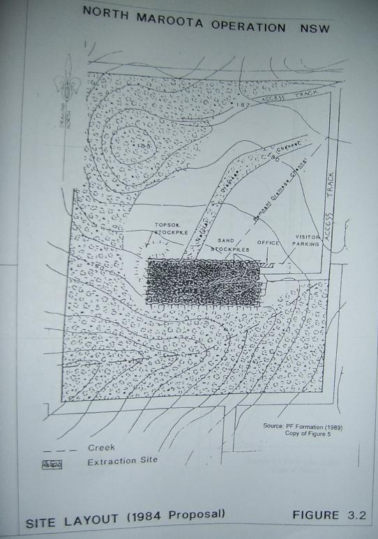
1984 – shown in DS EIS 1999 at Figure 3.2
August 2007 – DS SEE – p14-15 image
of Lot 196
In 1999 an Extractive Industry Report (“EIR”)
of BHSC/Officer Peter Zadeian (“PZ”) was challenged by DS in the Supreme Court, and the result apart from local
political controversy was that the court declined to prevent the EIR from going forward for the information of councillors.
DS argued the EIR was seriously flawed. DS was closed down by BHSCon the strength of the EIR by PZ in particular for lack
of progressive rehabilitation.
We understand SREPP 9 requires sandmining to be
done in an environmentally progressive
We understand there has been little or no progressive
rehabilitation on Lot 196 up to 2008. Indeed the feeling is that the DS could well be wound
up at any time and avoid any rehab cost (beyond the inadequate rehab bond monies) in decades to come depending on how long
it can obtain soft approvals and extensions.
Dust
and noise impacts on local area
There is no wheel wash at Lot
196 operated by DS. The photo Figure 3.1 in the SEE shows significant sand deposits on the tar Access Road. With more trucks
there will be more dust impact.
Wind comes sweeping up the plain such that cars
get sandblasted. This material can cause dust silicosis over time.
We understand excess levels contrary to EPA guidelines
affect the school – refer PF Formation Annual Reports dust monitoring for
around 2001-03.
The recent PF Formation Environmental Assessment
showed an exceedance of EPA guidelines. Refer page 113 of the PF Formation Environmental Assessment Hitchcocks Rd 2007, involving
averages over a month which hardly addresses particular days of prevailing westerly winds with much higher intensity:
One of the monitoring sites (Maroota Public School) is approximately 1,200
metres to the north, closer to other sand mining operations while the other two are on the boundary of the current operations
but within the Hitchcock Road site itself. Maximum
annual average dust deposition rates are above the criterion of 4 g/m2/month at all these locations, ranging
from 4.4 g/m2/month to 4.9 g/m2/month.

We submit the truck increase should be rejected
because the extra traffic compounds the dust problem.
We understand DS is licensed for 60 MegaLitres
per year and they must be illegally accessing over that limit given the 500K tonnes per annum volume extracted, even allowing
for comparatively higher quality sand (to PF Formation at Trig Hill Area, or 198 with high clay content).
Thus any additional water used for dust suppression
will compound this exceedance of their water licence.
The images provided by DS in the SEE show almost
total lack of rehabilitation from 1984 through to the present and this has only compounded the dust problem.
There is a right of way known as The Haul Road
which allows extractive industry traffic to travel from Lots 1 and 2 on the northern side of Lot
117 and 196 through the PF Formation site at 198 and up various crown roads to Wiseman’s Ferry Rd. This right of way bypass’s the school. The traffic past the school is
a major concern to students and teachers and families. If Dixon Sands with proposed increase in vehicles were to bypass the
school there would be less impact.
This would also mean less noise on Mr Accurso
which truck noise from DS exiting Access Road to Northern Rd
exceeds the EPA guidelines.
We understand there is an agreement between DS
and Accurso to accommodate these exceedances outside the planning legal framework. Presumably this agreement would need to
be renegotiated for the greater noise and dust impact.
Excessive
water usage contrary to Ecologically Sustainable Development principles
The minister is bound to consider principles of
ecologically sustainable development as per the Anvil Hill and Sandon Point cases of the last year. Similarly we note SREP 9 paragraph
4 Ecologically Sustainable Development. Water usage has been highly controversial at Maroota at least since 1996, that
is during otherwise higher rainfall periods which itself suggests some very excessive impacts on neighbour lands.
See for instance this govt brochure (copy at
Appendix J)
We also note the Director
of DOP criteria for the EA inclusion of "The NSW Groundwater Dependent Ecosystems Policy" DLWC 2002, with reference especially
to Management Principles at pages 21 -25 found via PDF file here:
In summary here:
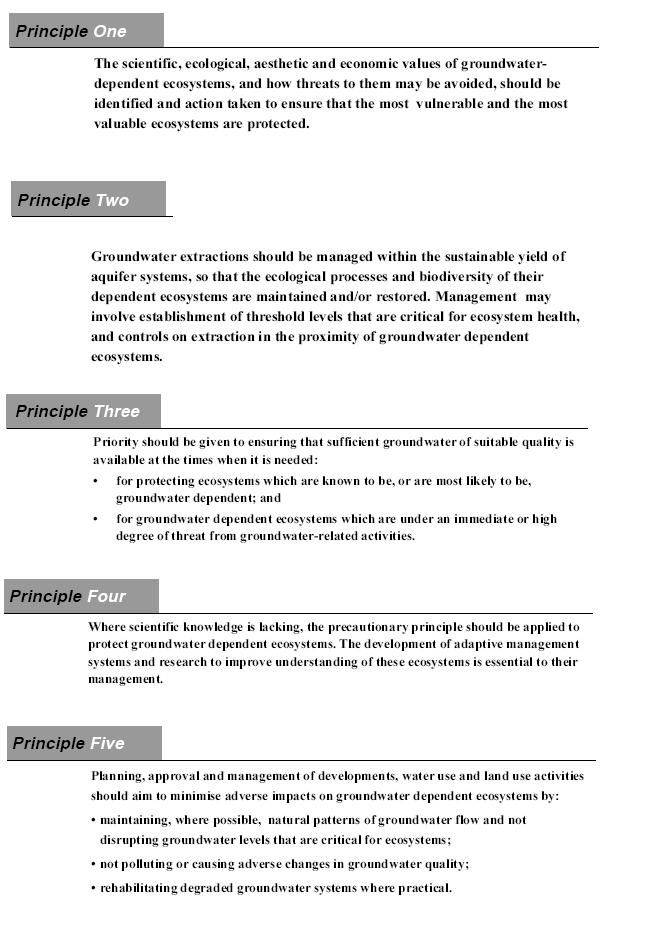
We are concerned that
the five principles there have not been fully addressed and resolved in the SEE.
Water
use
In relation to ESD as it applies to water resources
we submit there has been a long history of unlicensed and excessive water usage by PF Formations and no doubt other sand miners
in Maroota:
DS have dams never licensed under the Water Act 1912 or Water Management Act 2000
We note the past history back to the 1990ies of
illegal pumps at Maroota indicated here by a gold star from past inspections by objector Neville Diamond. This indicates of
culture of non compliance in the Maroota precinct:
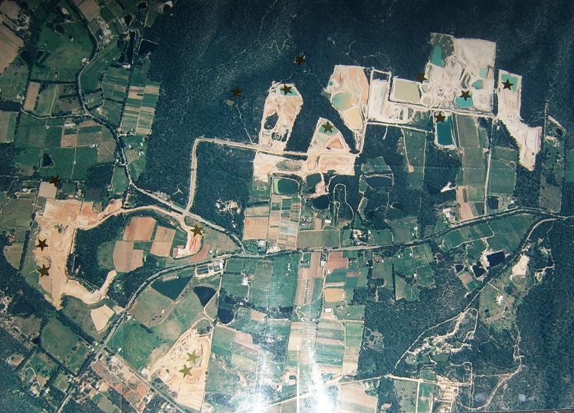
Picture above: Lands Dept aerial
photo 1998 with gold star indicating unlicensed water pumps at various times over the last 20 years in Maroota: Photo also visible in colour at this website http://www.sydneyalternativemedia.com/id158.html
We remain concerned that the SEE does not contain
adequate water balance or water management plan and when combined with the history of illegal pumps as shown above we submit
this is a recipe for massive over exploitation of the local water resources.
Failures
of regulatory governance of the sand extractive industries in the Maroota District
The failure of local and state government local
department)s) to strongly administer the cowboy sandmining industry at Maroota means that the sand is being sold artificially
too cheap as low as $15 a tonne, delivered. This means there is no financial component in the price for rehabilitation externalising
the impact to the future and probably the public purse, if ever.
We understand that statewide the Dept of Water
Annual Report 2005-2007, 2006-7 p28 reports no prosecutions statewide for breaches of the Water
Act 1912 in either year, only 2 penalties for the Water Management Act 2000
in 05-06, none in 06-07, and only 1 prosecution under the Rivers & Foreshores Improvement Act 1948. These low figures
of enforcement are derisory compared with 90,000 ground water bores and 13 900 surface water licences according to the 06-07
Annual Report.
DS EISs have pictures of massive exposed areas
contrary to best practise.
DS were shut down by BHSC in 1999 for bypassing
their approved staging plan.
We understand two officers have been put forward
as compliance officers for the DOP to monitor DOP consents of sandmining at Maroota. One of these officers is ex EPA and was
in charge of all the previous monitoring under the BHSC consents. In the last 20 years we believe the EPA have not taken any
meaningful action to enforce that environmental regulation. In particular we refer to the pitiful lack of concern by the EPA
at the threatened smothering of now listed endangered ecological community (NSW Scientific Committee) adjacent to Lot 198 in 1996 as set out in the materials here:
1996
EPA unresponsive to threat of dam failures at Maroota from heavy rain
At http://www.sydneyalternativemedia.com/id173.html
…………………………
Signed:
Thomas McLoughlin, pro bono solicitor, objector
And jointly and severally for Neville Diamond
objector
Appendix index
A1. history of litigation by Neville Diamond while working for and/or in association with Dixon Sands (Penrith) Pty Ltd
1997 .
A. Notice from Dept of Planning (DOP) to objector
Neville Diamond dated 25th January 2008 “under “section 96AA of the Environmental Planning and Assessment
Act 1979” (EPAA).
B. Allegations of corruption by objector Neville
Diamond dated 23 January 2008 in this respect, submitted to Minister Koperberg responsible for DWE.
C. Extract of evidence of Ken Dixon as patriarch
of Dixon Sands vaguely acknowledges groundwater usage on Lot 196 in the 1999 litigation between Dixon Sands (Penrith) Pty Ltd v Baulkham Hills Shire Council case no. 40130/98 & 10757/98 before Lloyd J as
follows
D. Figure 3 in the “1984 EIS” showing
perched water table on Lot 196 (full name “PF Formation/ Environmental Impact Statement/ Dam construction/ Portion 196 Old Northern Rd Maroota/ Collin C. Donges
& Associates Pty. Limited/ February 1984”) .
E. Extract of “1989
EIS” constant references to the intrusion into the groundwater on Lot 196 and surface springs in the area, full name “PF Formation/ Environmental Impact Statement Extension of Existing Extractive Industry
Portion 196 Old Northern Road Maroota/ Collin C Donges & Associates Pty Limited/
exhibition period 22/5/89 – 22/6/89), referred to as “1989 EIS”.
F. Extract Figure 8 (at Appendix F) used
by expert Donges in the 1989 EIS
G. Water usage comparative
expert data at PF Formation Trig Hill Area June 1998 - ERM McCotter expert report PF Formation
sandmining Maroota Trig Hill Area, Lot 198
H. The DS EIS 1999 Figure 3.1, 3.2, 3.3 showing
that creek lines described 1984 and 1989 (sourced from Donges for PF) then shown as vandalised by the 1999 diagram, as attached to technical paper Appendix C5 – Groundwater Impact
Assessment quoting Lyall & Macoun Consulting Engineers, in “Dixon Sands (Penrith) Pty Ltd/ Extraction, Rehabilitation and processing of construction
sands, Lots 196 and 29, DP 752025 North Maroota, NSW/ Southern Environmental Pty Ltd/ 15th February 1999 ” (referred to as the “1999 EIS”)
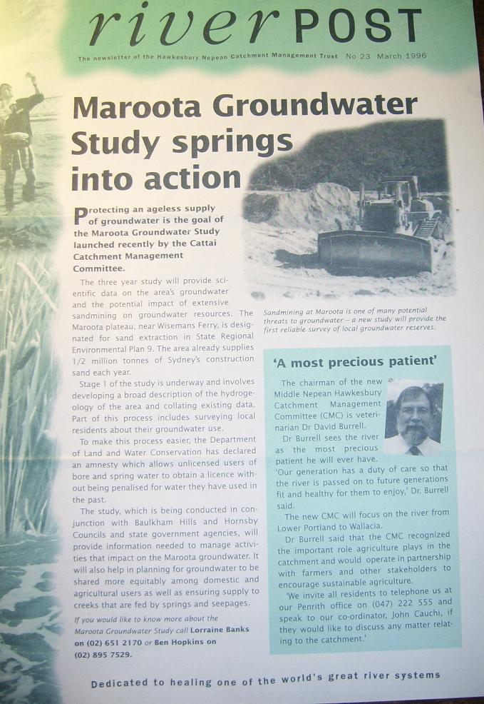
J. Maroota Groundwater Study brochure 1996.
…………………………………..