Date: 31st January 2008-01-27,
by email and by hand
To: NSW
Department of Planning, Major Projects (DOP)
Ground Floor, 23-33 Bridge St Sydney NSW 2000
Baulkham Hills Shire Council
Showground Rd Castle Hill
Attn: Director General
DOP
General Manager, BHSC
Stuart Bates, Investigation Officer BHSC
Dear Sir
Submission by Neville Diamond and
Thomas McLoughlin jointly and severally re
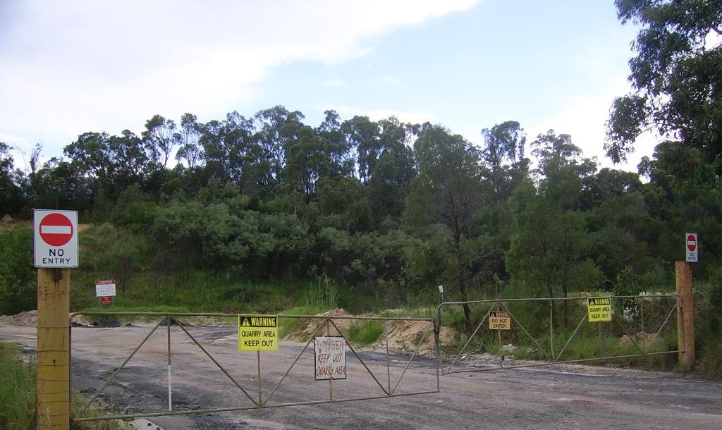
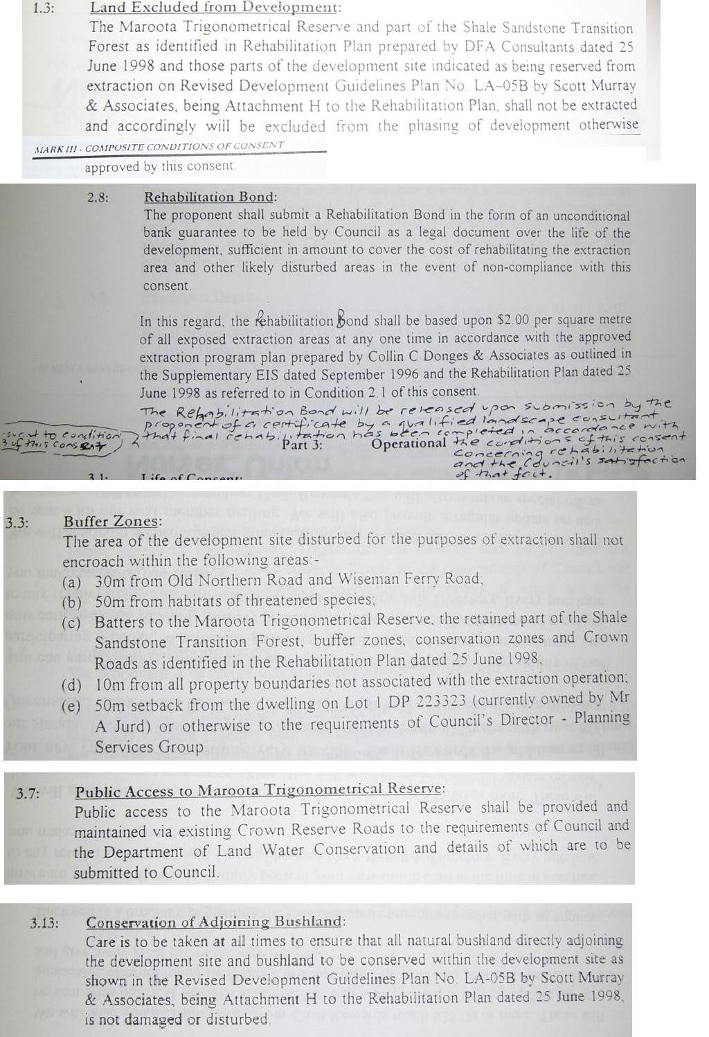
1. Objection to the development
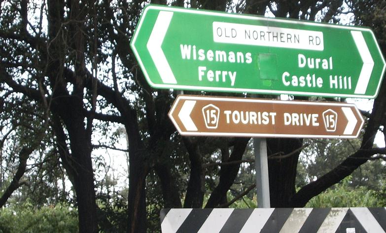
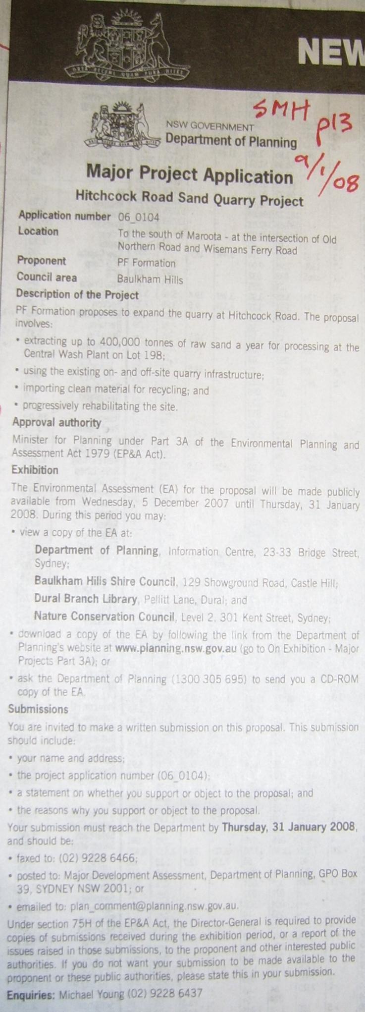
application (DA) in Environmental Assessment (EA) lodged by John Graham (JG) for PF Formation (PF) Project Application No.06-0104
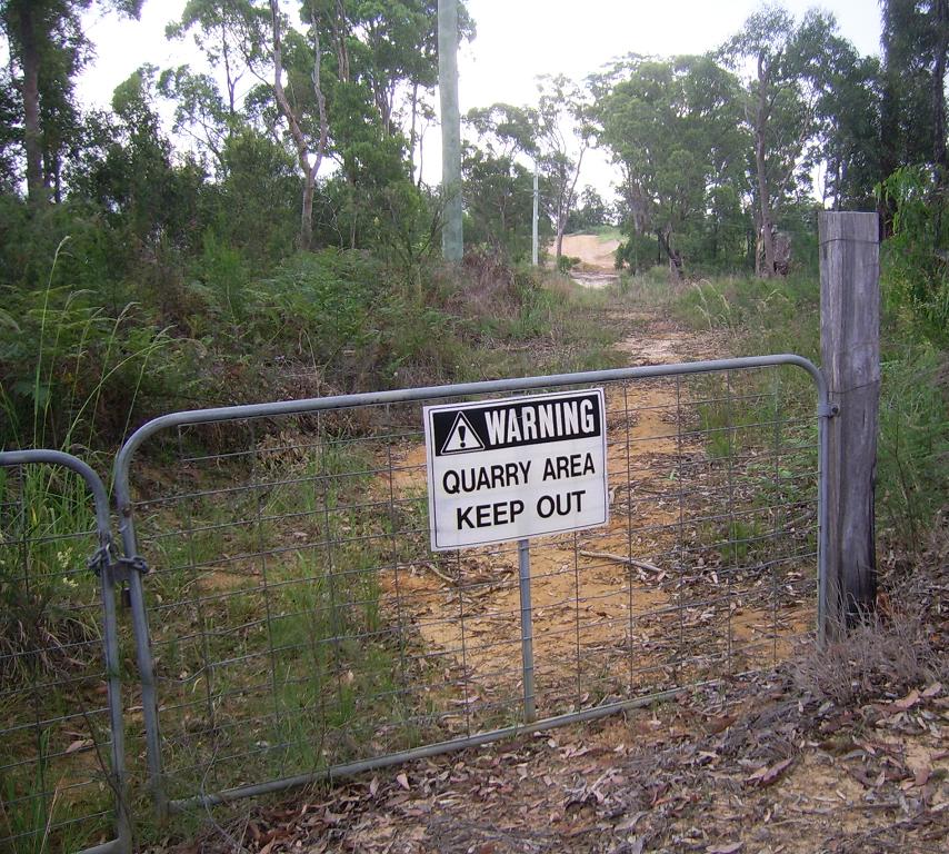
dated 3/12/07 for the Trig Hill Area ("THA")
2. Formal complaint to Baulkham
Hills Shire Council (BHSC) lapsed consent Trig Hill sand mine re lack of compliance with water licensing consent conditions
1998 prior to commencement of works, lack of progressive rehabilitation, other problems
Please note this submission is internet format based with embedded links and
colour photographs posted to the web at community media www.sydneyalternativemedia.com (currently at 19,000 page views per month):
Jan 08 - Objection to Maroota sandming unlicensed water use, failure to rehabilitate etc for 20 years
This submission is by
Thomas McLoughlin as editor of www.sydneyalternativemedia.com, principal of ecology action Australia
(unincorporated), and a solicitor in NSW, in his own capacity.
It is also
a submission jointly and severally for Neville Diamond by Tom McLoughlin as his
solicitor on a strictly pro bono basis in the public interest regarding ecological sustainability and due process.
Neither Tom McLoughlin,
nor any organisation he has worked for, or been a member of, has ever received any financial or in kind benefit or promise
of benefit in a financial sense, in relation to sand mining at Maroota or anywhere, or in relation to Neville Diamond (except
to say trivial secretarial disbursements of tens of dollars). This statement is made as a legal practitioner in NSW and applies
for all of the 1990ies to the present time.
It is a submission in
good faith in the public interest.
Introduction
We submit this DA is highly excessive for targeting sensitive bushland area
to access low quality high clay content sand, destroying a scenic lookout on public land, badly damaging local water resources
in the process. At the very least we urge the Minister to refer the DA to Dr Merrick who has been assessing the Somersby sand
mining DA which is open to him under Part 3A. In this respect we provide expert evidence in reports by ERM McCotter, and Sullivan,
below corroborating the hugely excessive use of water by PF Formation/Graham.
We also note that the EA will need to be re advertised due to misleading divergence
of the EA Summary on the DOP website compared to the CD and printed version copy in the EA itself for about 2 months from
Dec 07 to Jan 08.
Political/legal context
Regretably this DA is another exemplar of:
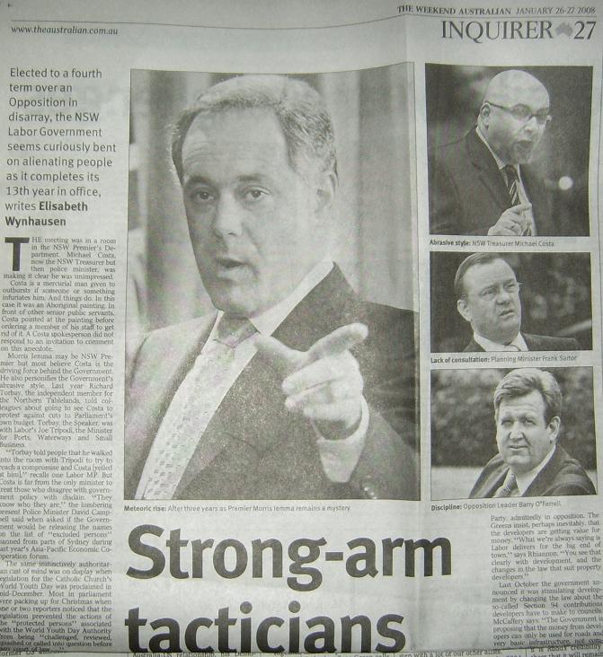
Strong-arm tacticians Elisabeth Wynhausen in The Australian 26th Jan. 2008
in relation to ramming through ‘major developments’ against community
standards and ecological sustainability.
In particular this quote:
"The minister [Sartor] can declare a
site to be "state-significant", giving developers the go-ahead on big projects. Under Part 3A of the Environmental Planning
and Assessment Act, projects that are objectively of state significance can go to the minister. Brad Hazard, the Opposition's
planning spokesman, says of the Government's planning actions: "The reality is that anything Frank wants to get his hands
on to, he takes."
This theme regarding the dictatorial and/or arbitrary use of Part 3A of the EPAA reversing
the proud history of the NSW ALP in Government from the intent and effect of the 1979 Act has been picked up extensively by
civil society as here:
1. NSW Nature Conservation Council background
paper at Major Projects (Part 3A) developments,
“Lack of transparency
The concentration of power in one person, the Minister for Planning, is bad enough, with clear implications
for corruption. To make this worse, the decision-making process surrounding Part 3A developments is unclear, with environmental
impacts, submissions from community groups and the public, and the thoughts of other government departments merely needing
to be 'considered' by Frank Sartor.”
Weakening
of other laws
Under Part 3A, many standard approvals are not required, meaning
effectively the Minister for Planning becomes the consent authority for these actions. Approvals that are no longer required
include: ….
- Clearing native vegetation or state protected
land (under Native Vegetation Act )
- Permit to excavate from riverbanks or
shore, or to interrupt the water flow (under Rivers and Foreshores Improvement Act) ….
- Water use approvals, water supply, drainage
and flood control works, controlled activities and aquifer interference (under Water Management Act) …
- Excavation permits, required for any likely
impacts on relics (European heritage) under the Heritage Act ….
Part 3A also changed the National Parks
and Wildlife Act so that developers will not be prosecuted for harming protected fauna without a licence, if the work carried
out is essential for Part 3A projects. ….
What
about environmental impact assessment?
For Major Projects, the Director General
determines the Requirements for environmental assessment. The Director General then writes a report to the Minister for Planning,
including a statement whether the developer's environmental assessment met the Requirements. The Minister must 'take into
account' this statement when deciding whether to approve the development. However, amendments made in 2006 – controversially
described as ‘housekeeping’ measures by Frank Sartor – mean the Minister can now approve a development application
under Part 3A whether or not the environmental assessment complies with the Director General’s environmental assessment
requirements.
For Part 3A projects, environmental assessment requirements are ‘tailored’ to a particular
project. This means that the Director-General determines the assessment requirements based on consultations with ‘relevant’
(as decided by the Director General himself) public authorities. Consequently, if the Director General misses something (e.g.
air pollution impacts) when writing the Environmental Assessment Requirements, then such impacts do not need to be investigated
by the developer.
The peak green groups Media Release from when Part 3A was introduced reads:
Law
removing community's right to appeal massive development passes
Friday, 10 June 2005
Environment groups are outraged that NSW Parliament last night
approved a Bill which makes major and alarming changes to environmental laws in NSW. Both major parties pandered to the development
industry, but set dozens of community groups against them, they said.
"The passage of this appalling piece of legislation represents
the greatest set-back in environmental protection laws in over 25 years. On his tenth anniversary as Premier, this Bill will
ensure that Bob Carr is remembered as the 'anything but green' Premier," said Cate Faehrmann, director of the Nature Conservation
Council of NSW.
"The Bill gives the Minister for Infrastructure, Planning and Natural
Resources largely unchecked powers when assessing the most significant and potentially environmentally damaging projects.
"The Government was hard-pressed to even demonstrate the need for
granting such broad, discretionary powers to the Minister. The best example they could come up with to justify this dangerous
piece of legislation in Parliament was a bridge collapse over the Derwent River in Tasmania - which occurred
decades ago," said Ms Faehrmann.
"The Bill is so flawed that even the Coalition saw fit to propose
amendments which would have provided at least some checks and balances limiting the Minister's broad discretion.
"But Coalition concerns over the Bill in the end amounted to mere
rhetoric. If the Opposition were serious about addressing community concerns they would have supported a move to refer the
Bill to a Parliamentary Committee for Inquiry," said Jeff Angel, Director Total Environment Centre.
"An Inquiry would have been entirely appropriate, particularly
given the level of community concern and lack of consultation surrounding the introduction of the Bill.
"The fact that this Bill was ultimately approved by both sides
of politics is a clear indication of how little public opinion matters and how much the property industry matters to both
Labor and the Coalition. But you can't win government by just pleasing the developers and there is now a big hole in the parties'
community credibility," Mr Angel said."
See also their Position Paper on Part 3A in particular:
· That an independent
body, with members appointed by relevant groups/organisations rather than by the Minister, replace the Minister as the consent
authority for the purposes of Part 3A.
· That equal weighting
and consideration be given to social, economic and the principles of ecologically sustainable development (ESD) when determining
each development application. This should take into account previous decisions and cumulative
impacts.
2. NSW Environmental Defenders
Office - EDO Public Seminar – “Part 3A and the Public
Interest” Cate Faehrmann, Nature Conservation Council of NSW - listen to speech [23:47 mins] Cr Sam Byrne, Local Government and Shires Association - listen to speech [19:20 mins] More information on the Part 3A amendments For a brief overview of the recent planning reforms, the EDO has assessed the current state of play. [PDF 92 KB]
Note the EDO July 2007 states:
“The new Part 3A reforms in 2005 introduced
a new way of doing planning and development in NSW. The reforms were based on laws introduced by Premier Joh Bjelke-Petersen in Queensland in
the early 1970s: the State Development and Public Works Organisation Act 1971. These rode roughshod over community consultation
rights.” Jeff Smith Principal Solicitor, EDO
July 2007
Also note:
EDO Paper Part 3A Technocratic
Decision-Making and the Loss of Community Participation Rights: Part 3A of the Environmental Planning and Assessment Act 1979
by Ian Ratcliff, Jessica Wood and Sue Higginson updated Feb 2007
Also note:
EDO letter Rachel Walmsley Policy Director dated 25 May 07 to Sector Strategies and Systems Innovation Department of Planning Re: State Environmental Planning Policy
(Major Projects) including:
Additional
approvals
The consequence of the listing of a class
of development as a Part 3A project under the Major Projects SEPP is that certain licences and approvals required by other
Acts are no longer required. Under s75U of the Environmental Planning and Assessment Act 1979, t hese include: the concurrence
of the Minister administering the Coastal Protection Act 1979, approvals under Part 4 of the Heritage Act 1977, permits under section 87 and section 90 of the National Parks and Wildlife Act 1974 and water use approvals under sections 89-91 of the Water Management Act 2000
These other approvals constitute important
safety nets, and help ensure that all potential impacts of a development are adequately considered when the Minister makes
his decision. The departments that are responsible for granting these additional approvals have the necessary expertise to
adequately assess issues such as pollution, heritage and threatened species licences. The listing of a class of development
under the Major Projects SEPP means that these issues may be validly ignored. Furthermore, even those approvals that still
apply under Section 75U (such as an Environmental Protection Licence) cannot be refused. Given these consequences, the EDO opposes the listing of classes of development as Part 3A projects. Developments should be considered
individually to determine whether they are appropriate for consideration under Part 3A.
Also note:
Environmental
Assessment of Major Projects and Critical Infrastructure
Major
Projects
The environmental assessment requirements
for major projects and critical infrastructure are far more discretionary than the requirements for developments under Part
4, and activities under Part 5 of the Environmental Planning and Assessment Act 1979.
Once a development or activity is declared
by the Minister, or identified in the Major Projects SEPP as a major project, Parts 4 and 5 of the Environmental Planning
and Assessment Act 1979 no longer apply to the project, nor do the provisions of Local Environmental Plans (LEPs) or Regional
Environmental Plans (REPs). Whilst the permissibility of a proposed major project in the provisions of a LEP or a REP is a
matter for that the Minister must consider in determining whether to grant consent to a major project, the fact that a project
is prohibited in a LEP or a REP will not necessarily prevent it from being approved. ….
State Environmental Planning Policies also
do not apply to major projects unless the policy expressly states that it applies to the particular project. Part 3A also
sets out different environmental assessment requirements for major projects
Unlike the provisions of Part 4 of the Environmental
Planning and Assessment Act 1979 which require proponents of integrated development applications to obtain additional approvals
under other legislation, such approvals are not required for major project approvals. Approved major projects are exempt from
having to obtain the following approvals:
- concurrence of the Minister for development
within the coastal zone under the Coastal Protection Act 1979.
- permits for dredging or damage to mangroves
or seagrasses or to obstruct the passage of fish under the Fisheries Management Act 1994.
- approval under the Heritage Act 1977 for
works affecting properties listed on the State heritage register or for excavation works which may affect relics. In addition,
an interim heritage order cannot protect a heritage building, work, relic or place from being destroyed in order to carry
out an approved major project.
- permits under the National Parks and Wildlife
Act 1974 to interfere with or destroy Aboriginal objects.
- consent to clear native vegetation under
the Native Vegetation Act 2003.
- permits to excavate the bed or shore of
rivers and coastal lakes and lagoons under the Rivers and Foreshores Improvement Act 1948.
- bush fire safety authority under section
100B of the Rural Fires Act 1997.
- water-use approvals, water management
approvals and activity approvals under sections 89-91 of the Water Management Act 2000.
In addition, the following orders and notices
cannot prevent an approved critical infrastructure project from being carried out:
- an interim protection order under section
91A of the National Parks and Wildlife Act 1974 to protect significant areas or areas which may contain threatened fauna or
flora.
- a stop work order issued under the National
Parks and Wildlife Act 1974, the Threatened Species Conservation Act 1995 or the Fisheries Management Act 1994.
- an environment protection notice issued
under the Protection of the Environment Operations Act 1997.
- an order made under section 124 of the
Local Government Act 1993.
Once a major project is approved by the
Minister, there is little another authority can do to prevent the project from being carried out. If an approved project requires
an aquaculture permit, mining lease or environment protection licence under other legislation in order to be carried out,
then another authority is not permitted to refuse that approval.
The clear implication is that
planning in NSW is under control of a modern ‘Mussolini style’ autocracy, making the DA ‘train run on time’
with hardly any democracy or justice, for instance as regards in this specific case:
- need
for future water licensing (now repealed) in a very water stressed location both for neighbours and the immediate environment
due to unlicensed overuse in breach of the 1998 and 1989 consent.
- Extreme
failure to follow progressive rehabilitation requirements 1998 or 1989 consent.
- Protection
of a public land heritage lookout on Trig Hill from extreme vandalism including
destruction of sensitive vegetation and private profiteering for sand mining profits off public land.
DOP/Applicant misleading and deceptive
conduct in publishing divergent EA summaries
We submit that the EA will have to be re advertised for procedural fairness
to all stakeholders for the following reason: This DOP version was copied to our hard drive and printed out to evidence the
very substantial confusing, deceptive and misleading variations from the CD/printed
copy of the EA (which are the same) from the DOP website version as detailed in the compilation of variations in Appendix A, with printed version of the DOP website version at Appendix B
The summary EA is found at the DOP website as follows:
On exhibition - Major projects - NSW Department of Planning at
http://www.planning.nsw.gov.au/asp/major_projects.asp
viewed Saturday 26th Jan, Sunday 27th January 2008 specifically:
………………………….
· Proposal title: Hitchcock
Road Sand Quarry Project (MP 06_0104)
· Description:
PF Formation proposes to: extract up to 400,000 tonnes of raw materials a year for processing at the Central Wash
Plant on Lot 198; use the existing on- and off-site quarry infrastructure; import clean material
for recycling; and progressively rehabilitate the site
· Location: To
the south of Maroota - at the intersection of Old Northern Road
and Wisemans Ferry Road
· LGA: Baulkham
Hills
· Exhibition
locations:
- Department of Planning, Information Centre, 23-33 Bridge Street, Sydney
- Baulkham Hills Shire
Council, 129 Showground Road, Castle Hill
- Dural Branch Library, Pellitt Lane, Dural
- Nature Conservation Council,
Level 2, 301 Kent Street, Sydney
· Approval Authority:
Minister for Planning
· Relevant Legislation:
Part 3A of the Environmental Planning and Assessment Act 1979
· Proponent:
PF Formation
· Submission
to: Director, Major Development Assessment, Department of Planning, GPO Box
39, Sydney NSW 2001
· Start date:
5 December 2007
· Closing date:
31 January 2008
· Documents available:
Project application, summary of the environmental assessment, Director-General's requirements for Environmental Assessment. The Environmental Assessment can be viewed online at: http://www.pfformation.com.au/__Pages/hitchcock road development news 1.htm
· Further inquiries:
Michael Young on (02) 9228 6437
……………………
In particular embedded URL of summary of the environmental assessment is http://www.planning.nsw.gov.au/asp/pdf/06_0104_summary_of_the_ea_for_dop.pdf
Other formality and substantive
irregularities in the DA/EA
It appears the EA has not been signed by the consultants to the DA who prepared
it.
It is unclear who is the proponent – “PF Formation” which
formerly was the trading name of Etra Pty Ltd in 1998, or another corporate entity of similar name to PF Formation such as
PF Formation No.1 Pty Ltd or PF Formation No.2 Pty Ltd, or John Graham or any of these or another legal entity.
In the document itself at p3 1.1.2 The
existing quarry there is no mention of Lot 198 in the Description of the site Table
1.1 in terms of ownership, though Lot 198 is mentioned elsewhere in the EA as the location
of the washplant. This seems unduly narrow categorisation of the quarry site given the central role Lot
198 plays in the excavation. We understand that in 1998 Lot 198 was owned by Etra Pty Ltd.
Indeed this appears to follow a strategic approach from the 1998 litigation
of attempting to exclude as much focus from the highly sensitive Lot 198 as possible given
a long track record of leaks and breaches of the 1989 consent conditions, and illegal excavations.
In this respect we include copy of photographs of Lot
198 taken in late 1996 by this writer:
1996 - Maroota Lot 198 PF Formation/Etra Pty Ltd impacts Maroota Sands Swamp Forest listed as an endangered committee by the NSW Scientific Committee (at Appendix F)
Legal requirements for honest EA
information nor misleading/deceptive
in the course of business
We note via
TRADE PRACTICES ACT 1974 - SECT 52
Misleading or deceptive conduct
(1) A corporation shall not, in trade or commerce, engage in conduct that is misleading or deceptive or is likely to mislead or deceive.
(2) Nothing in the succeeding provisions of this Division shall be taken as limiting by implication the generality of subsection (1).
Similarly we note the NSW equivalent:
FAIR TRADING ACT 1987 - SECT 42
Misleading or deceptive conduct
42 Misleading or deceptive conduct
(TPA s 52)
(1) A person shall not, in trade or commerce, engage in conduct that is misleading or deceptive or is likely to mislead or deceive.
(2) Nothing in this Part shall be taken
as limiting by implication the generality of subsection
Our brief discussion with Jeff Smith as principal at the Environmental Defenders
Office suggests that a fair trading legal complaint is potentially open to us even in a Part 3A type DA which seeks
to shut down legal scrutiny. This is presumably because honest business people as much as publicly minded environmentalists
want reliable and credible terms of trade in commerce and business, including information in a sandmining EA or approval process.
And also
ENVIRONMENTAL PLANNING AND ASSESSMENT
REGULATION 2000 – REG 283
False or misleading statements
283 False or misleading statements
A person is guilty of an offence if the person makes any statement, knowing it to be false [bold added] or misleading in an important respect, in or in connection with any document
lodged with the Director-General or a consent authority or certifying authority for the purposes of the Act or this Regulation.
We note the subjective knowledge test is absent in the fair trading legislation,
and that it is presumably an objective test whether the market has been misled.
It seems to us that either knowing or
unknowing supply of misleading or deceptive information in one or other of the EA summaries, or in the EA proper is in breach
of these fair trading provisions in the course of business, trade & commerce, at NSW and/or the federal version of this
law. We are taking further legal advice on this. We note the EA summary error above but also other misleading and deceptive
information below.
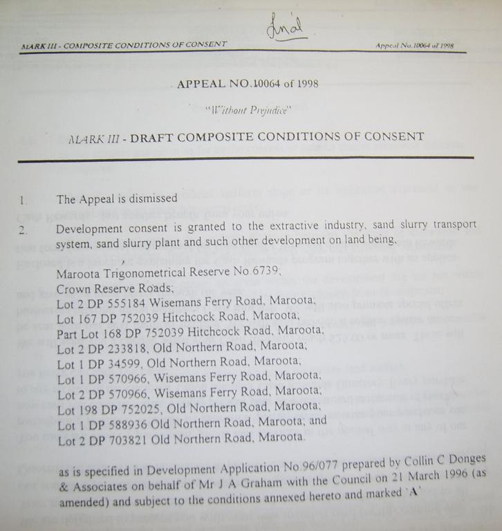
Litigation history – 1998
case law
In 1998 a similar DA made to BHSC was challenged in the Land & Environment Court
in Diamond v BHSC and John Graham (PF Formation/Etra Pty Ltd No. 10061/1998) and
much tougher conditions of consent were legally negotiated by way of settlement of the legal dispute with all parties paying their own very substantial legal costs. These conditions of consent were “without prejudice” by either side. In other words the challenge was so
meritorious that presumably BHSC counsel felt no costs order was reasonably possible
by BHSC, nor did JG for the challenge to the BHSC consent because there were such substantial changes in the negotiated conditions
outcome.
This is quite contrary to the spin in the EA stating blandly the appeal was “dismissed”
A third party
filed a Class 1 Appeal against the consent in March 1998. This was heard in the Land and Environment Court in July 1998 and the appeal dismissed.
[at page 16
- all references to the EA summary are to the printed/CD version]
This was the legal formality. In reality it was a tough negotiation probably unduly generous to the sand miner given Diamond’s financial
limitations in gathering more damning expert evidence, with Brian Preston as counsel representing BHSC who literally wrote
the book on “Environmental Litigation” (1989) and is now Chief Justice
of the Court. Bruce Woolf represented Neville Diamond and the co author of this submission Tom McLoughlin was assisting pro
bono paralegal via green group Friends of the Earth Sydney Inc in 1998.
‘Key approval conditions’ go way beyond the spin bottom of p16
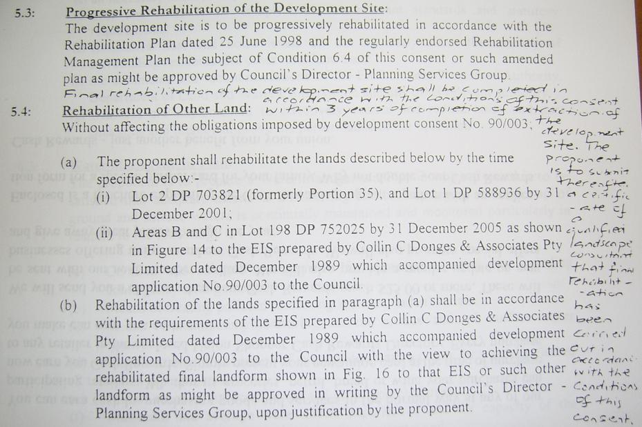
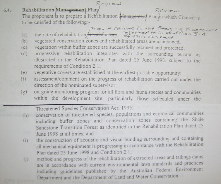
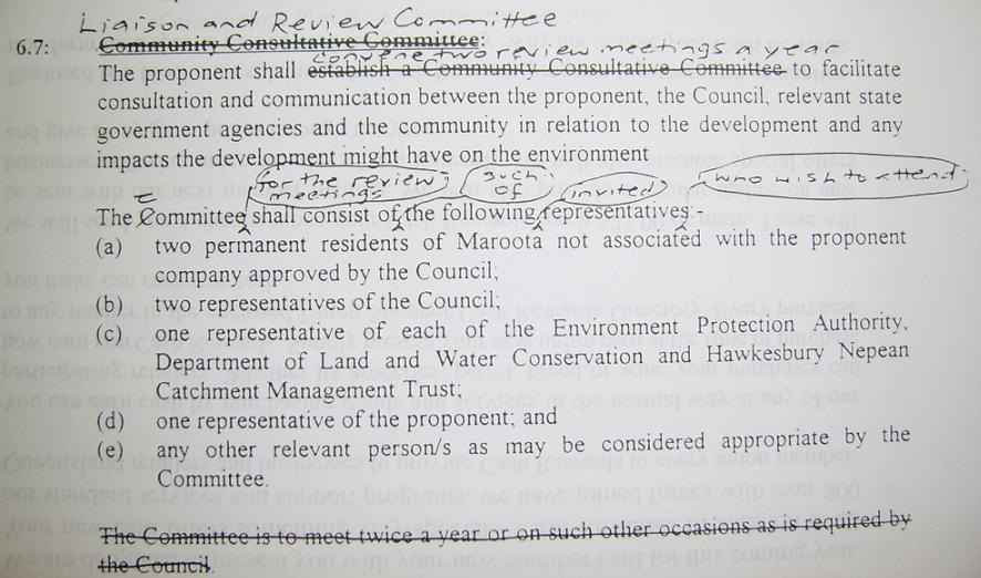
to 17 of the EA summary. We include a full copy of the consent conditions with
this submission:
Rather than “sterilise” volume of tertiary sand, it protected a
local heritage land mark and scenic lookout on public land, and also with endangered community of shale sandstone transition
forest listed on the NSW Scientific Committee.
A full copy of the consent conditions as agreed (including handwritten notations
in the court precinct in 1998) are enclosed at Appendix C particularly relevant to the conditions of progressive rehabilitation which we believe the current sand mine is in wanton
breach of since 1998, and breach of from the previous consent in 1989 before that. In other words we see no reason to trust
this sandminer on compliance of DA conditions 10 years later or in the future.
The EA summary bravely claims:
The extraction has subsequently been operated in compliance with Consent
Orders 10064 of 1998 of the Land and Environment Court
dated 14 July 1998. [p16]
The site is operated in compliance with these and other conditions included
in the
consent orders administered by Baulkham Hills Shire Council. [p17]
We will demonstrate that this repeated claim of compliance is false and misleading,
and may well be knowingly (hence omission of the full consent conditions of 1998 from the EA?), not least lack of rehabilitation
and failure to license water usage.
In this respect we refer to this community media report of the current sand
mine with recent photographic evidence at Appendix D, also at Sydney Alternative Media 15th January 2008 (community
news service with 18,000 page views per month):
Tuesday, 15 January 2008
Sandminer in bid to avoid rehabilitation legal rules at Maroota, 45km from Sydney?
We discuss further below another blatant breach on and around this site pre
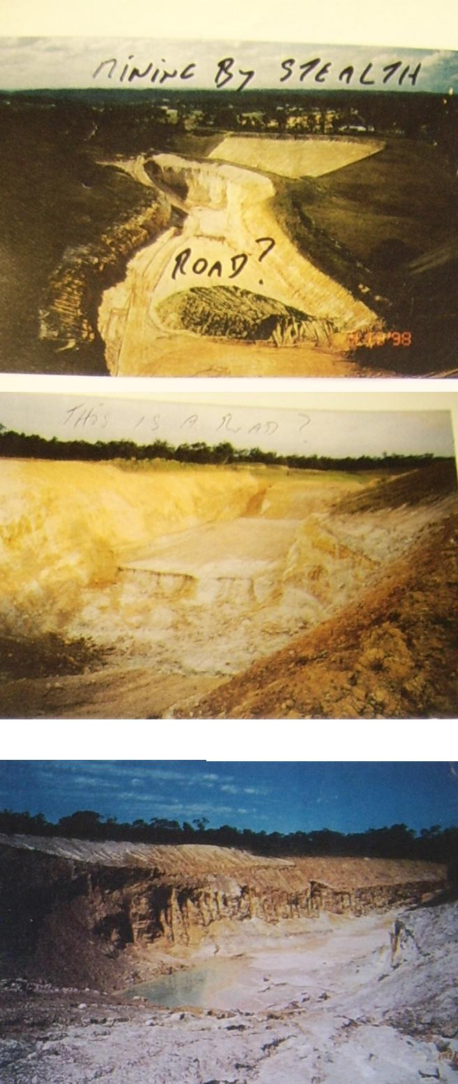
1998 being the 1995 infamous ‘road to nowhere’ involving 3 years of illegal sand mining, to a depth of 30m for
a road approval at 4.5m, a breach effectively sanitised by the 1998 DA BHSC proposed approval partly amended by Diamond in
the Land & Environment Court in 1998.
Balanced approach of objection to
Dixon Sands (Penrith) Pty Ltd (“DS”)
environmental impacts in Maroota
In terms of balance regarding other sandminers Neville Diamond (“ND”)
advises:
The Extractive Industry Report of BHSC/Officer Peter Zadeian (“PZ”)
was challenged by DS in the Supreme Court around 1999, and the result apart from local political controversy was that the
court declined to prevent the EIR from going forward for the information of councillors. DS argued the EIR was seriously flawed.
DS was closed down on the strength of the EIR by PZ.
In terms of even handed approach ND did legally challenge then Dept of Infrastructure
& Natural Resources (DIPNR) approval of DS 2003 application (Lot 196 expansion)
on the basis (inter alia) of unlicensed water use.
We understand DS obtained a consent in 2004 for Lot 196 and Lot 1 and Lot 2,
and Dixon got another consent soon after in Sept 05.
Re DS approval Haerses Rd Sand Quarry early 2006 (major development). ND did
not challenge this approval due to other pressing business namely court challenge of Birdon Contracting P/L (owner Tom Bruce)
at Tinda Creek in 2006 due to (inter alia) unlicensed use of water.
The history of ND work with and for DS in litigation against PF Formation can
be found at Appendix M .
Excessive water usage contrary to
Ecologically Sustainable Development principles
We understand that despite the dictatorial nature of the Part 3A regime gutting
the EPA Act the minister is still bound to consider principles of ecologically
sustainable development as per the Anvil Hill and Sandon Point cases of the last year. Similarly we note SREP 9 paragraph 4 Ecologically Sustainable Development.
Water usage has been highly controversial at Maroota at least since 1996, that is otherwise higher rainfall periods which
itself suggests some very excessive impacts on neighbours to sandmining, especially as regards high clay content areas like
Trig Hill Area and Lot 198.
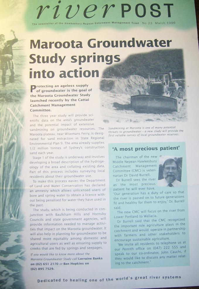
See for instance this govt brochure:
We also note the Director of DOP criteria for the EA inclusion of "The
NSW Groundwater Dependent Ecosystems Policy" DLWC 2002, with reference especially to Management Principles at pages 21 -25
found via PDF file here:
In summary here:
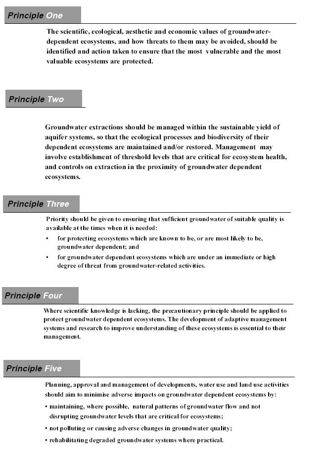
We are concerned that the five principles there have not been fully addressed
and resolved in the EA.
We also refer to
- Max Taylor/Toomakoo Pty
Ltd letter to BHSC 27 October 1988 attaching extract of Geological Survey of NSW DMR “Geological investigation and resource
assessment of the Maroota Tertiary Aluvial Deposit by L..T. Etheridge” at Appendix C1
- David Taylor BSC Agri (soil
Sc,, MBA, Ad Cert Man, Manager Hawkesbury Technologies Ltd, expert evidence report June 1998 in Diamond v BHSC/Graham/Etra
Pty Ltd/PF Formation, at Appendix C2
In relation to ESD as it applies to water resources we submit there has been
a long history of unlicensed and excessive water usage by PF Formations and no doubt other sand miners in Maroota:
DS, and PF both have dams never licensed under the Water Act 1912 or Water Management Act 2000 and there are probably
other dams by other miners similary not licensed. Specifically illegal water use during the watch of Peter Zadeian (PZ) up
to 2001 and Christine McKenzie post 2001 at BHSC involved a small window created by PF Formations into the water table on
the Trig Hill Area (“THA”) about 1995-6. This was then expanded to the present far larger window which is now used as a dam capturing all the surface water from THA - 7 parcels of land mostly
owned by PF. The dam on 167 has never been licensed under the Water Act 1912 or
Water Management Act 2000.
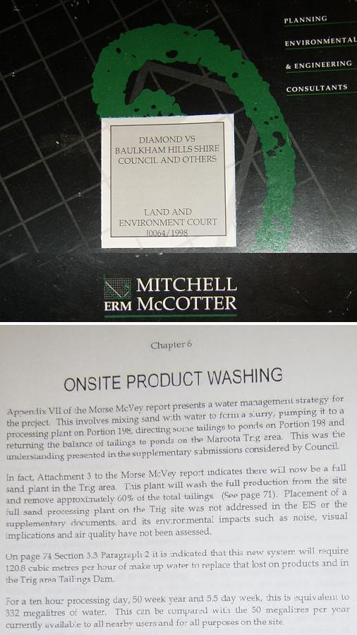
ERM McCotter Report (produced for
ND in the 1998 litigation Diamond V BHSC & Etra Pty Ltd t/a PF Formations 10064
of 1998) over the same THA extraction operation states that PF were using an estimated 332 megalitres - when in fact at that time in 1998 they were only licensed for 50 megs. In actual fact under DLWC license
that 50 megs was to be shared by 4 different users inclusive of PF and neighbours
Toomakoo P/L lemon farmers, Black market gardener, and Roberts market gardeners. Extracts of
the ERM report follow and a full copy is at Appendix C3
The Sullivan Report of 1998: This
unlicensed water usage raises the question where is PF sourcing it, and what impact was it having on the other 3 neighbours
already forced to share the 50 megalitres. ND advises they were all under duress
over water because PF well prior to 1998 had already mined out of area and breached the water table on THA affecting the recharge
of the aquifer which fed the springs to Toomakoo/Taylor, Roberts and Black land. ND submits the DLWC granted the 50 megalitre
shared license on or about 1995 as a compromise resolution of that breach of the aquifer and the failure of the DLWC to alert
BHSC of the impact on water supply of the 1989 consent for THA to PF. The background detail to the damage to the aquifer is
in the expert evidence in a report for ND in 1998 litigation by Sullivan Environmental Consulting which unfortunately was
too late to be considered by the court in 98 but was filed in the court and provided to PZ and BHSC and PF Formation. For
instance see extract attached at Appendix C4.
For instance Sullivan reports at page 3 that
“The Woolley 1980 letter
acknowledges Mr Tayler’s concern that the proposed removal of sand deposits would adversely affect the supply of water
from the spring and states that “mining along his eastern boundary would probably reduce the flow from the spring by
more than 50% because it would eliminate the flow of groundwater from the main recharge area.
The [Woolley] letter advises that
“the proposal to extract sand and gravel from the Maroota deposit will have an affect on the groundwater resources of
the area in that it will remove most of the material which now both facilitates recharge from rainfall to the groundwater
system in the area and provides storage for this water.”
The letter to Baulkham Hills Council
concludes that “It is regretted that the groundwater situation was overlooked when the Commission commented previously
on the mining proposal.”
In 1980 Mr Woolley was a senior
hydrogeologist with the Water Resources Commission and I understand that he is presently in a similar position with the Department
of Land and Water Conservation (DLWC)
We understand this to mean that Woolley substantially agrees with Taylor as far back as 1980 about significant or even 50% reduction in flow of spring water that Taylor depends on at his place to the west of extraction of sand deposits
on THA. (Woolley is held in very high regard as an expert for instance the NSW Government appointed him to do in 2006 an expert’s
“Peer Review of Technical Reports” for Sydney Catchment Authority,
Avon Nepean areas). This view of Woolley is supported by Ethridge in 1980 (see
extract attached in Appendix C1):
“Extraction of sand below
the water table in the area near Hitchcock s Road would effectively cut off groundwater flow from the main intake area to
the Haerses Road area.”
Sullivan, a very experienced expert in his report of June 1998 just out of
time for the litigation by ND, further evidences this predicted eventuality of damaged water resource foreseen by Woolley
and Ethridge back in 1980. Sullivan states:
“[at p 3] The report on Mr
Taylor’s spring comprises a letter from Woodward-Clyde (signed by Dr Carosene) to PF Formations dated 3 April 1995 which
was prepared following the publication of an article in a local newspaper.
I am advised by Mr Taylor that
the yield values for the spring used in Dr Carosene’s evaluation are incorrect to a major degree. Rather than an original
daily yield of 7000L the actual flow rate measured by Mr Taylor for April 1980
was 388,000L/day and the flow rate measured in March 1995 was 52,300L/day rather than the 2000 to 3000L/day indicated in the
background section of the letter. The spring flow is understood to have remained at this lower level to the present time.
The site observations section appears
to generally agree well with my observations during my January/February 1995 inspection. It is noted that the elevation of
mining at this time was about RL 180m, which is significantly lower than the RL 187m, regularly referred to in the documentation
relating to the proposal for additional mining, as the lower limit of mining. Although the area of ponded water was about
15m in diameter my recollection was that the surrounding area, (about 3 ha) mainly to the north and east was only a little
higher (say RL 181-182m) and much of the area appeared wet.
My recollection of the descriptionof
Mr Taylor’s spring concurs with that of Dr Carosene’s except however that the yield at that time (early 1995)
would have been about 40-50% of the
storage volume available. …..
I have combined the information
provided in the earlier report by Etheridge with the information provided in Figure 2 of the April 1995 letter report to produce
the attached Appendix B. The marked up cross section sections shown in this Appendix provide my assessment of the most likely
‘before mining’ groundwater flow regime for comparison with an ‘after mining’ flow regime.
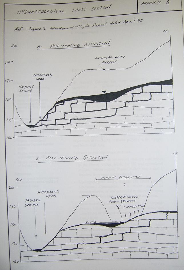
As indicated by this figure the
flow into the spring is considered most likely to have been significantly reduced from the 388kL/day flow rate measured in
1980 to the 52kL/day measured in 1995. The reasons for the reduced flow are considered to be as follows:
· removal of some 137kL/day (50ML/year) under licence by the mining activity, resulting in a much lower flow from the
perimeter of the sand aquifer;
· evaporation of some 30kL/day from an area of about 3 ha (which has a very shallow water table) based on a net evaporation
rate of 1 mm/day;
· a reduced head of groundwater in the Maroota sands which will result in a significant reduction in the flow through
the underlying sandstone.
I strongly disagree with Dr Carosene’s
conclusion that he considers it highly unlikely that the Tayler spring has been affected by the sand mining operations. On
the contrary I consider that the information available clearly indicates that the significant reduction in yield of the Taylor spring is most likely to be a direct result of the sand mining activities on Lot
167.”
We submit that this expert evidence from Sullivan confirms very great impact on the water resource by sandmining at the
THA up until June 1998. We submit logically that such impact can only be greater by sandmining by Graham/PF Formation up until
2008 in the same general location, or at any time beyond.
Of interest is that ND allegation that a bureaucrat running the Maroota Groundwater
Study, Dan McKibbon (DIPNR/DWE) “lost” a year’s pumping figures from the DIPNR monitoring bores which apparently
confirmed the sandmining at Maroota precinct including THA caused significant reduction in the water table. We find this losing
of critical data very curious and suspicious and strengthens our view the current proposal should go to a credible expert
inquiry. We understand Mr McKibbon is a consultant with Parsons Brinckerhoff for the EA for PF Formation in the current DA
before the DOP.
ND alleges that neither of these reputable and highly professional reports
by Sullivan or ERM McCotter or the implications of them have ever been provided to the elected councillors of BHSC despite
the opportunity. Further the BHSC have not provided this information to the Dept of Planning for the current DA which is virtually
the same are3a as the 1998 DA which was limited to some degree by the legal settlement conditions of the litigants before
L&E Court with each party paying their own costs.
The socio-economic effects at p28 of the print CD EA, completely omits the
significance of excessive water usage on all other neighbouring water users as per the Sullivan and ERM McCotter Reports in
the 1998 litigation.
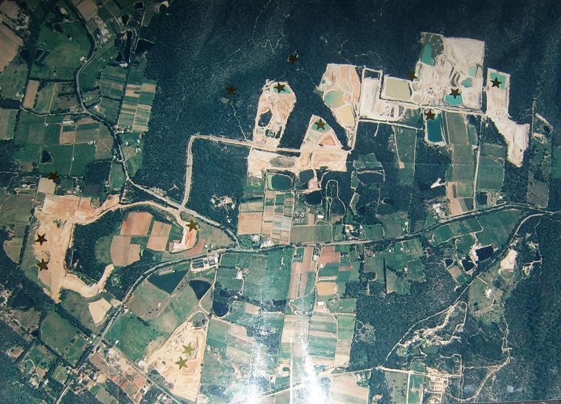
We note the past history back to the 1990ies of illegal pumps at Maroota indicated
here by a gold star from past inspections by ND:
We remain concerned that the EA does not contain a water balance or water management
plan and when combined with the history of illegal pumps as shown above we submit this is a recipe for massive over exploitation
of the local water resources.
Is it really a “major project” or simply an attempt to avoid 1998 Land & Environmennt Court rehabilitation
settlement conditions? Evidence of avoidance of s.94 contributions
We note the criteria for major project status here:
STATE ENVIRONMENTAL PLANNING POLICY (MAJOR
PROJECTS) 2005 - SCHEDULE 1
SCHEDULE 1 – Part 3A projects-classes of development
(Clause 6)
7 Extractive Industries
(1) Development for the purpose of extractive
industry that:
(a) extracts more than 200,000 tonnes of
extractive materials per year, or
(b) extracts from a total resource (the
subject of the development application (or other relevant application under the Act)) of more than 5 million tonnes, or
We question whether in fact the development will generate more than 200K tonnes
p.a. or more than 5 million tonnes given the high clay content of the Trig Hill. The EA Summary does not name a figure for
the volumes per annum possibly because they cannot evidence such volumes either above or below 200K pa without running into
trouble on accounting for s.94 contributions?
The explanation for this as we understand is that there has never been a quantity survey of sand mining in this area by PF Formations (or other sand miners
in Maroota to our knowledge), nor is this adequately addressed by survey measurements alone or alternative accounting by weigh
bridge which is susceptible to compromise and cheating: We provide pictorial evidence of avoidance of the PF Formation weigh
bridge below taken about 1998 with the Dixon signage showing illegal exit from PF Formation site in north west Maroota in
the opposite direction to the weighbridge at Lot 198 and legal exit way:
Significantly ND alleges that he, David Dixon and David Dixon’s driver
in about 1998 tracked approximately 100 tonne of sand being delivered from the northern most PF extraction site in Maroota
by way of avoidance of the weighbridge with delivery some 5 km away to the Camelleri property (named as an associated land
owner in this proposal p3 Table 1.1). This and other pictures were taken at the time as evidence:
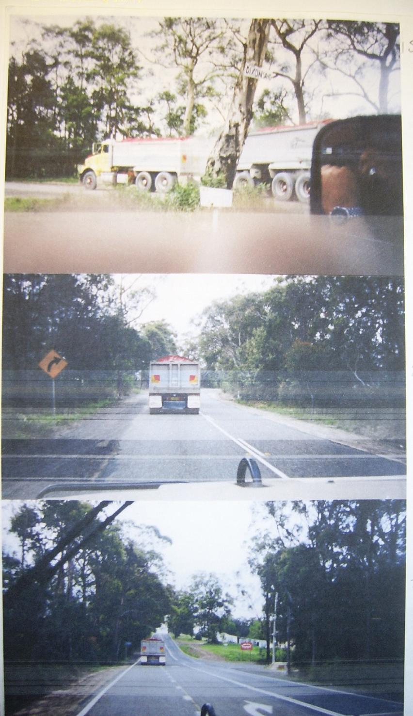
In other words we submit there is a culture of avoidance of the weighbridge
and no accurate credible volumetric auditing of extraction volumes. We understand in the early 90ies that BHSC, in response
to public complaints about integrity of s.94 accounting that the council retained an auditor from Truman & Associates
to study this question of volumetric measurement of the extractive industry in order to accurately account for s.94 developer
contributions. We understand that ‘audit’ was woefully inadequate and unconvincing and treated with little credibility
by most stakeholders. Apparently its inadequacy was kept secret for up to five years by BHSC by refusing to release the report.
History of bad faith by John Graham/PF
Formation in relation to Lot 167
- the internal haulage road that became
a massive sand mine in breach of 1995 approval on this site?
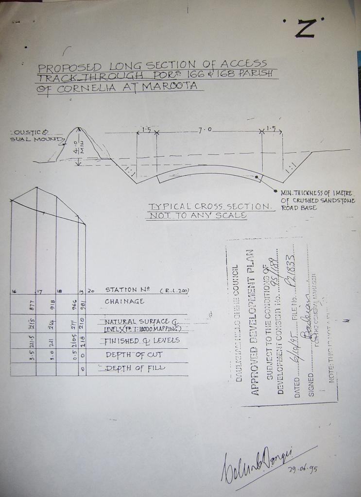
Neville Diamond advises the DA 95/189 of 1995 to BHSC construction of a private
access road for later use of an internal haul road system on lot 167, DP75209, Lot 198 and Lot 1 and 2 on DP 570966, which
was approval for a 4.5 metre depth and 13 metres wide (refer figure following) was then constructed in breach of the DA to
30 metres deep and 100 – 200 metres wide. This was a controversy in the local
press at the time: “An accusation over excavation” 1998 Hills District
Times with local resident James Gouskos estimating 300,000 tonnes of sandy material from what was meant to be a 4m road
construction: As per these images taken in 1998
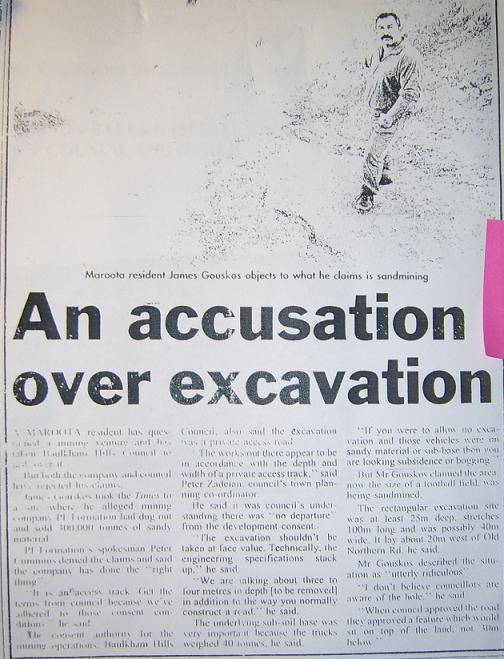
What was the BHSC role in the ‘road to nowhere’ breach of the DA
depth and width conditions which facilitated the illegal excavation of the area around the THA 26m deeper than the approved
4.5 m depth?
Diamond alleges that council officer Zadeian misled the local press, the councillors
in the relevant Extractive Industries Report and later Justice Lloyd in the Land & Environment Court and solicitors for BHSC (possibly through another council officer Michael Watt) by ignoring the breach of depth
limit and hiding behind a letter of a geotechnical expert for PF dated 21
Dec 1995 (Appendix E) about road specifications and clay base which never intended to, nor could of itself, authorise as an expert adviser to PF
Formation a 26m deep, 100m plus wide exceedance of the internal road consent conditions. The massive volume excavated on the
flimsy basis of a road may not have been subject to full s.94 development contributions for export of sand. It seems to us
in light of the photographs above of truck avoiding the weighbridge above the company willing to exceed the road depth by
26 m would have little problem driving around the weigh bridge to defraud the public revenue of s.94 contributions as well.
ND advises he and David Dixon and Dixon’s
driver tracked fully laden PF Formation sand trucks exiting via an unauthorised side road starting lot 1 then public road
right next to lot117 (this is the Dixon access road off limits
to PF Formation). This was in 1998. Diamond calculates 100 tonne to Camelliri
Place 5km away via this avoidance method.
- illegal operation of Lot
198 through out the 1990ies?
Refer to our photographic
evidence at Appendix F in relation to the endangered community of Maroota Sands Swamp Forest as listed by the NSW Scientific Committee, and correspondence of 17th April 1998 to BHSC at Appendix H for more general concerns of cowboy operations of the Maroota sand extraction sector as per a lengthy submission regarding
failures of BHSC to maintain effective regulation of the sector.
- vandalism evidence in 2000 of the
Shale Sandstone Transition Forest on Trig Hill public reserve post Land & Environment Court decision 1998
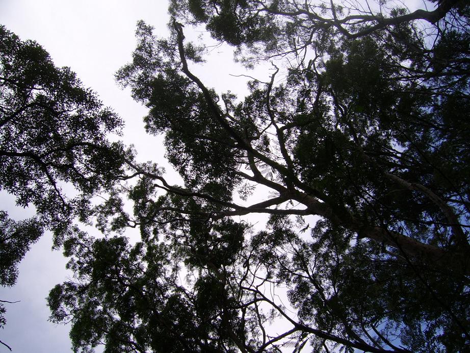
Refer Appendix G for photographic evidence in 2000 taken by Tom McLoughlin of vandalism of the SSTF on the Trig Hill site, and refer to this listing of the NSW Scientific Committee.
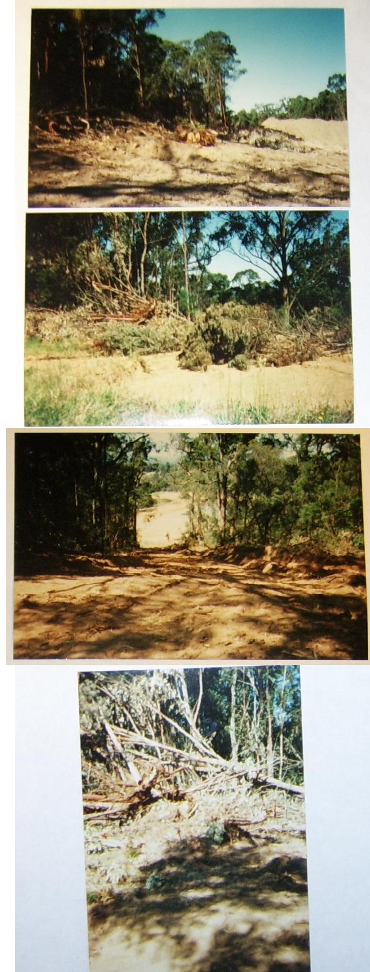
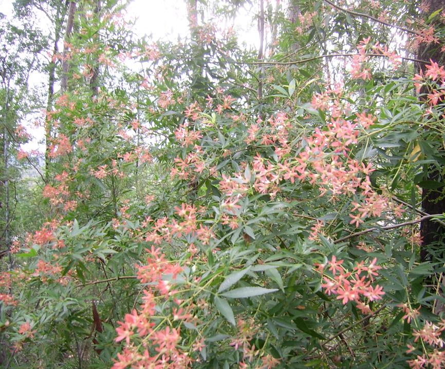
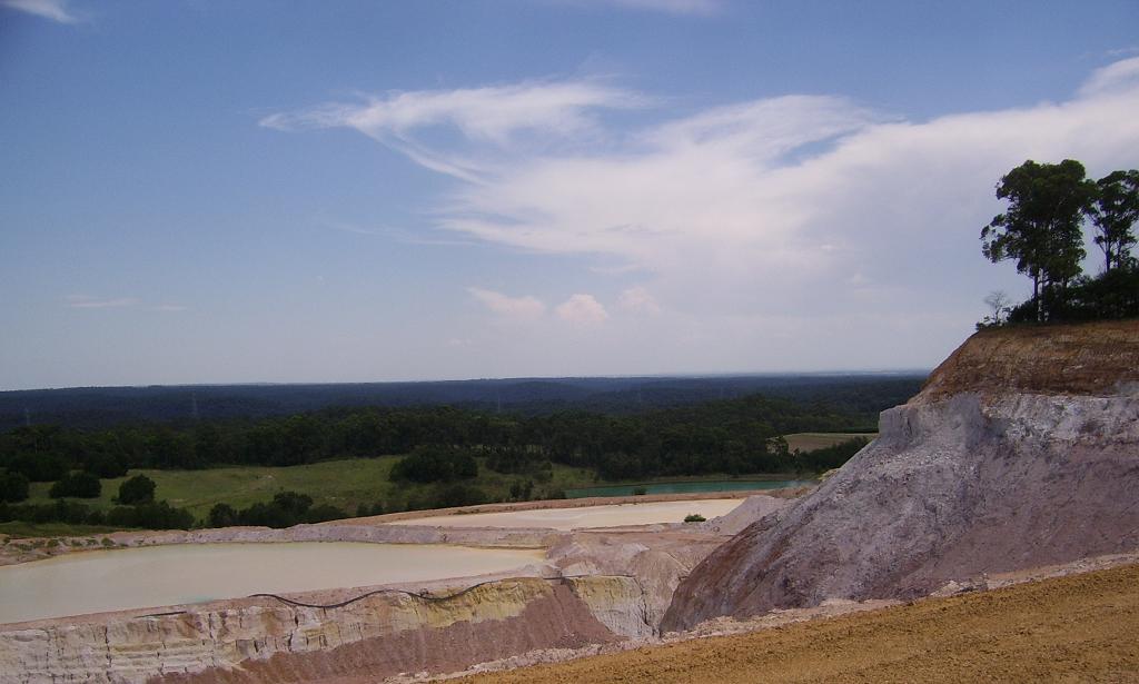
Further images of the quite good quality and aesthetically appealing apex of
Trig Hill SSTF forest taken by this writer in January 2008 can be found at Appendix J.

- disturbing grant by the Dept of Lands
officer of public heritage lookout Trig Hill to private lease of PF Formation sandminer in defiance of the terms of Land & Environment Court 1998 decision
The legal settlement condition of 1998 to Graham/Etra Pty/PF Formation states:
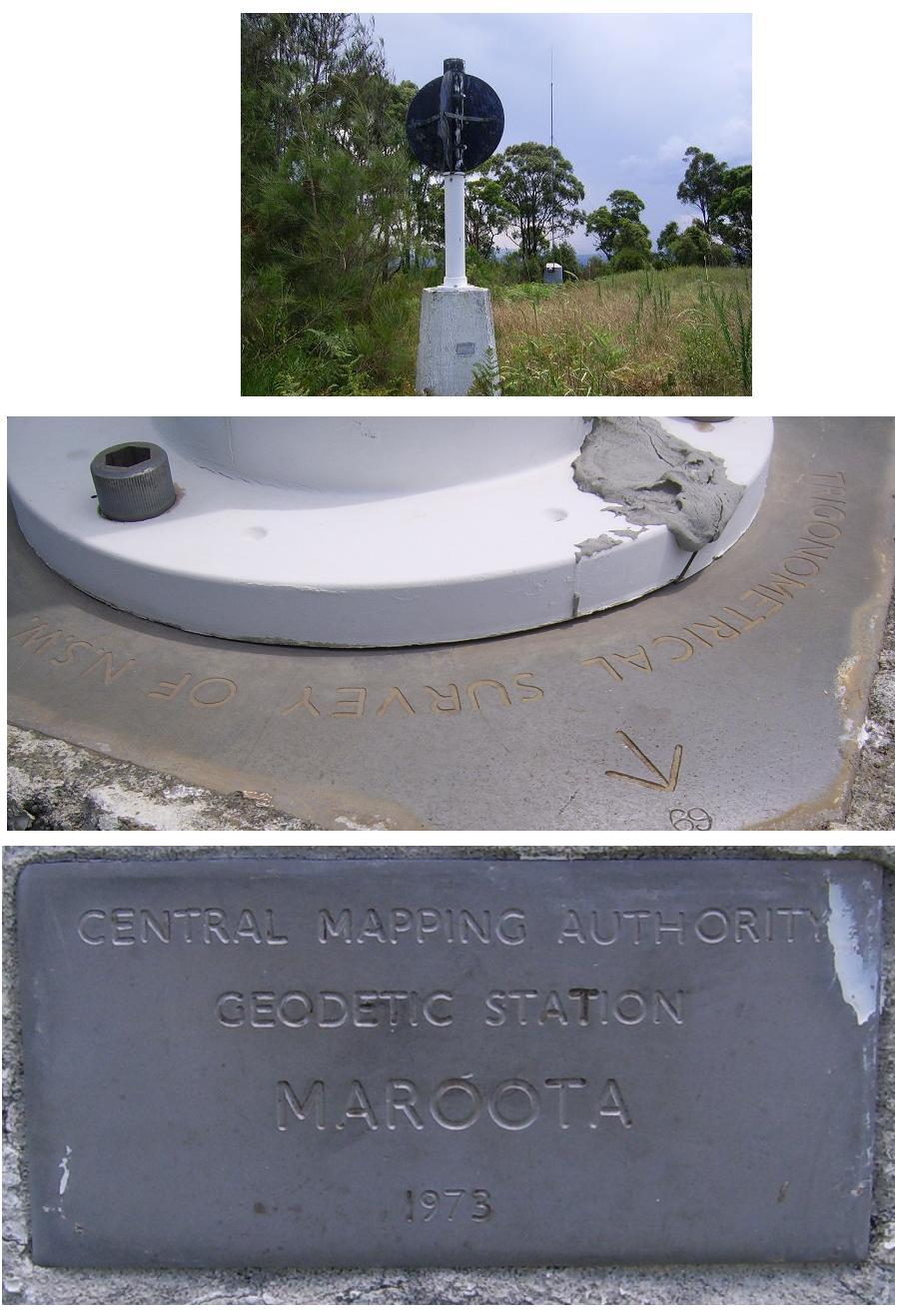
3.7 Public Access to Maroota Trignonometrical Reserve:
Public access to the Maroota Trigonometrical
Reserve shall be provided and maintained via existing Crown Reserve Roads to the requirements of Council and the Department
of Land Water Conservation and details of which are to be submitted to Council.
There seems to be a pall of mystery over how a private lease was granted over
the THA by the stroke of a pen of a Lands Dept officer, when even BHSC as far back as 1998 had itself been determined to exclude
this area from the sandmining operations not least because it was established as an important cultural site for the local
community. This is made very clear in the BHSC report of Peter Zadeian dated 12 December 1997 as per the extract of section 3.2 at Appendix K
Was the lease on a proper basis? Did the lease terms have payment of rent,
payment of future sand mining royalties? Why has the public lost access to its historical/heritage scenic lookout to view
the whole surrounding district (and likely was the use by colonial settlers and Indigenous before that). Local historian Geof
Bucchan held cultural events in the 90ies when it was still public access.
ND alleges that his FoI inspections of the Lands Dept files indicated a serious
argument between Lands Dept officers over the lease grant with the officer (George Forster?) stating in effect ‘there
was nothing on it’ and another referring to in fact there being forest (indeed forest listed by the NSW Scientific Committee).
If true, this is a scandalous turn of events suggesting the excessive influence of the sandminer to subvert regulation in
the district, with the assistance of what we imagine to be an ignorant, negligent Lands Officer or worse.
In the current proposal in the EA Summary
under Cultural Heritage p26-27 the alleged lack of cultural heritage of the Trig
Station is tritely asserted and does not resolve the heritage significance of the scenic lookout, landscape and aesthetics.
- comprehensive failure of progressive rehabilitation of land by PF Formation/Graham for
20 years
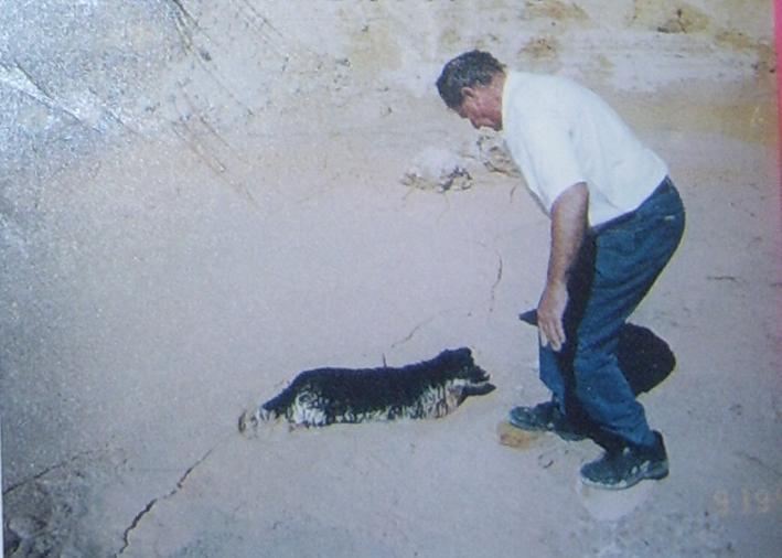
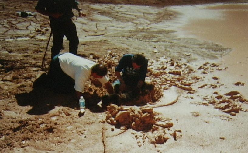
Picture: Trig Hill Area 30m deep ‘road’ slurry,
tame pet dog rescued purely by chance from dangerous quicksand stuck fast on community inspection day, Sept 1998.
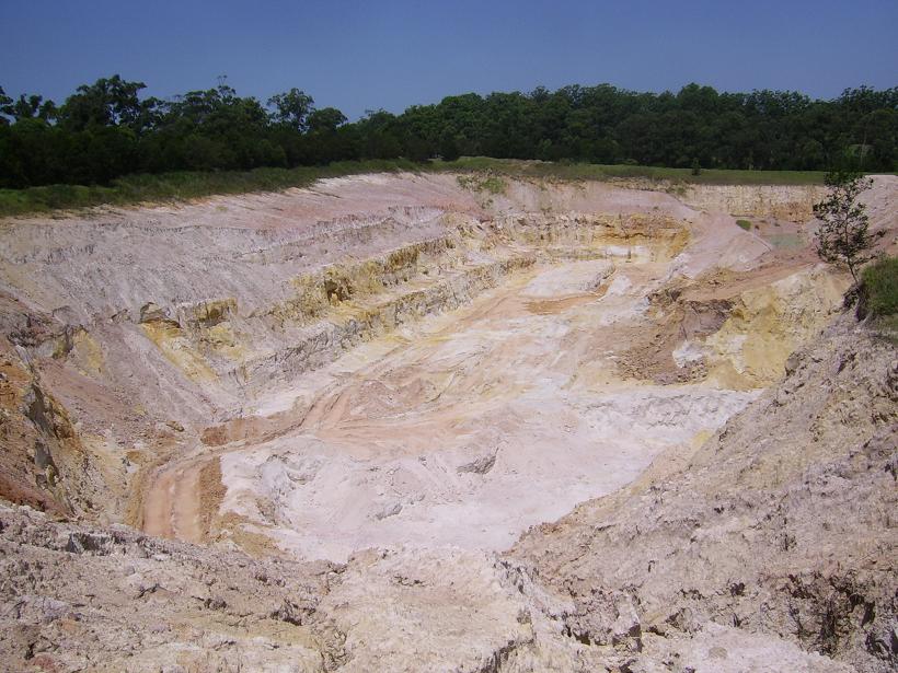
Print/CD version of EA Summary at p21 roman numbers reads:
Sand has been extracted from part of the site to the depth allowed
in the existing consent and part of this area has been rehabilitated.
In fact we understand there has been little or no progressive rehabilitation
contrary to the terms of the 1998 settlement terms of consent and timetable and very little prospect of any compliance. Indeed
the feeling is that the relevant company will be wound up and avoid any rehab cost in decades to come depending on how long
it can obtain unquestioning approvals. All experience directly contradicts page 22 of the EA Summary:
The majority of the site to be quarried would be rehabilitated with grasses
on the flatter slopes and local native plants on the batters and steeper slopes.
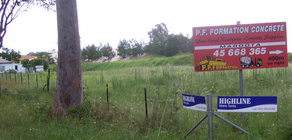
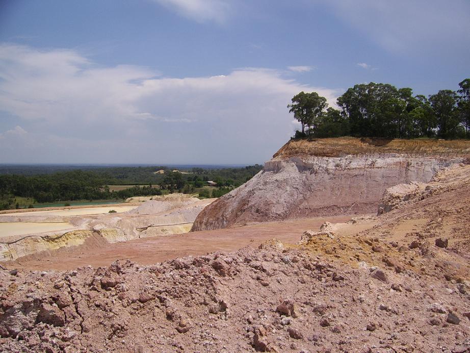
Indeed this photo immediately below from the Lands Dept from a aerial survey
map photo (THA at bottom left and Lot 198 at top right) 1st October 1998, cost $400, indicates the extensive sand mining 10 years ago with no rehabilitation since 1989 works commenced. When
this photo is compared to the site images in the EA of Dec 2007 one can see there has been practically no ‘progressive
rehabilitation’ whatsoever.
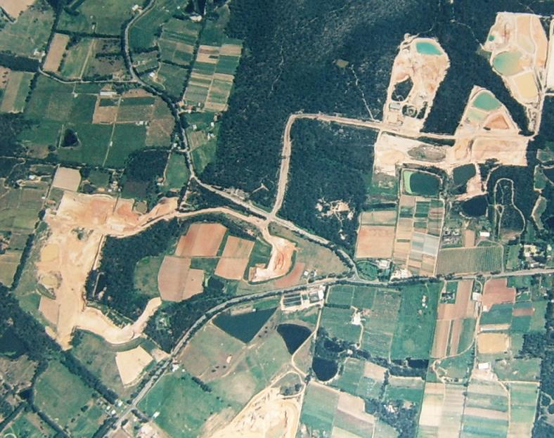
Pictures: Above is Lands Dept photo 1/10/98 Lot 167 Trig Hill area, below is EA Summary Dec 2007 evidencing
little or no rehabilitation for 10-20 years of PF Formation sandmining.
.
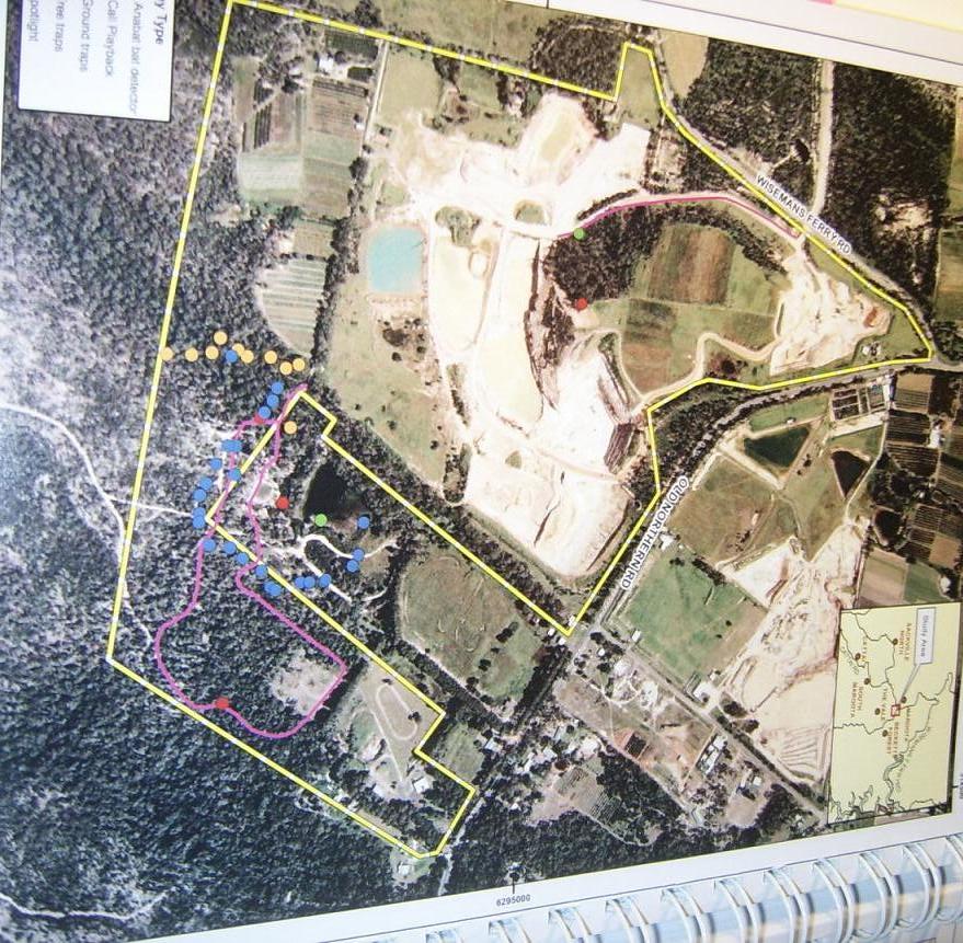
For an overall image of the whole Maroota Sand mining district go to Appendix L. taken by the Lands Dept 1st Oct 1998.
The rehabilitation bond is grossly inadequate. In the previous consents given
by BHSC the bond was $2 per square metre. In recent DA approvals as we understand it’s gone up to $3sqm. Currently we
understand there is $200K in the BHSC rehabilitation bond lodged by PF Formation for all their operations at Maroota under
BHSC. In theory if this current DA was rejected by the DOP we submit this is a hopelessly inadequate amount to pay for rehabilitation
of the Trig Hill consent area of ’98 including protection of existing vegetation.
Dust impacts on local area
In relation to dust wind comes sweeping up the plain such that cars get sandblasted.
This material can cause dust silicosis over time. We submit the advice of the air quality consultant in the EA is unsafe and
unreliable concerning this excessive dust coming from the west hitting the school and orchards:
We understand excess levels contrary EPA guidelines affect the school – refer PF Formation Annual Reports dust monitoring for around 2001-03. Dust meters are not
locked and can be tampered with easily enough, pretty obsolete technology when observed by ND in 2002.
Refer page 113 of the EA involving averages over a month which hardly addresses
particular days of prevailing westerly winds with much higher intensity:
One of the monitoring sites (Maroota
Public School) is approximately 1,200 metres to the north, closer to
other sand mining operations while the other two are on the boundary of the current operations but within the Hitchcock Road site itself. Maximum annual average dust deposition
rates are above the criterion of 4
g/m2/month at all these locations, ranging from 4.4 g/m2/month to 4.9 g/m2/month.
Failures of regulatory governance
of the sand extractive industries in the Maroota District
The failure of local and state government local department)s) to strongly administer
the cowboy sandmining industry at Maroota means that the sand is being sold artificially too cheap as low as $15 a tonne,
delivered. This means there is no financial component in the price for rehabilitation externalising the impact to the future
and probably the public purse, if ever.
We understand that statewide the Dept of Water Annual Report 2005-2007, 2006-7
p28 reports no prosecutions statewide for breaches of the Water Act 1912 in either
year, only 2 penalties for the Water Management Act 2000 in 05-06, none in 06-07,
and only 1 prosecution under the Rivers & Foreshores Improvement Act 1948. These low figures of enforcement are derisory
compared with 90,000 ground water bores and 13 900 surface water licences according to the 06-07 Annual Report.
Maps for PF Formation in the EA evidence virtually no rehab on THA or Lot 198 site contrary to best practice.
DS EISs have pictures of massive exposed areas contrary to best practise.
DS were shut down by BHSC in 1999 for bypassing their approved staging plan.
PF did exactly the same thing on the original consent in the late 80ies on
Lot 198 but BHSC took no action for reasons only known to officer Peter Zadeian (who was
later asked to resign for running a consultancy from council offices). Zadeian went on to work as a consultant for McCartney
who opposed the new consent for DS in 2002/3 , main competitor to PF (Qui bono?
– PF Formation).
Diamond alleges PZ fabricated council reports re PF from 95-2001 (at which
time he was asked to resign for misuse of BHSC facilities for private consultancy work which may or may not have been related
to sand mining). ND says he can prove fabrications/errors/deceptions/mistakes in council reports. These proofs re PZ are said
to be in 3 main areas:
1. Firstly On portion 167
(part Trig Hill consent – 1989) PF extracted out of area, from ‘89 to ‘98 according to ND reading of maps,
personal observations and complaints to BHSC. For instance an extracted area known as ‘zucchini patch’ (as called
by the residents) ND states as out of area (says boundary verified by the maps). This is rehabilitated mined area complimented
by PZ in his extractive industry reports while ignoring that it is also out of area and illegal (PZ Extractive Industry Report
16 June 1998 bottom page 22).
Extractive Industries Reports (“EIR”) are done every 6 months
for the whole Maroota mining precinct 1996-present. The EIRs under PZ oversight 96-01 were 20-30 pages long, reasonably detailed
albeit allegedly corrupt/incorrect in places. These EIR were so controversial DS challenged them in the NSW Supreme Court
in 1999 as inaccurate but the judge preferred to leave that to the political process of lobbying, even if inaccurate.
2.Secondly, ND alleges PZ
has completely ignored in both
- his
report for approval of the 1998 DA on the Trig Hill mining site by PF; and
- in subsequent EIRs on mining in the Trig Hill area
the expert evidence he and the council were provided with at the relevant
times also discussed above:
A. ERM McCotter Report
produced for ND in June 1998 litigation Diamond V BHSC & Etra Pty Ltd t/a PF Formations
10064 of 1998,
B. The Sullivan Report
of 1998.
ND advises that neither of these reputable and highly professional reports
or the implications of them have been provided to the elected councillors of BHSC. Further the BHSC have not provided this
information to the Dept of Planning for the current DA which is virtually the same study area as the 1998 DA which was limited
to some degree by the conditions agreed by settlement of the litigants before the Land & Environment Court with each party
paying their own costs.
3. Thirdly ND alleges a critical
Williams geotech advice letter (at Appendix E) on a shallow internal haulage road was selectively quoted in PZ’s EIR, and PZ effectively misled/allegedly perjured
(?) himself in evidence to Justice Lloyd in proceedings by BHSC v DS in 1999 (according to evidence on the stand in transcript of PZ evidence under cross examination,
around page 67 of that case, copies provided to DPNIR by ND).
ND alleges that these complaints were never properly investigated or resolved.
After 2001 EIRs were done by BHSC officer Christine McKenzie in a greatly different
style – only about 9 pages long, ¼ page per mine. ND alleges these sanitised true situation re failure of enforcement
of consent conditions omitted from the reports eg
- Deceptively
omits lack of rehabilitation
- Lack
of water licensing (legally required for each quarry prior to works commencing) and/or licenses insufficient for volumes used;
PF and DS lacked licensing for pump from clean water pond to wash plant, (as distinct from the license for the bore to the
deep aquifer that tops up the clean water pond);
State govt departmental governance of water issues has also been problematic
around
– licensing,
– failure
of Sydney South Coast regulatory section
– unresponsive
complaints system,
– misleading
the minister
– failure
of DLWC/Maroota Ground Water Study objectives
– failure
of SREP9 eg to provide a steady supply of sand following ESD, with no future plan
– abolition
of the Maroota Environmental Impact Consultation Committee (aka MEICC aka meek and mild committee!) later known as the MQCC
(Maroota Quarry Consultation Committee) by State Planning (ie DIPNR)
ND’s advises his role in litigation funded by and for Dixon Sands is
attached at Appendix M.
We understand two officers have been put forward as compliance officers for
the DOP to monitor DOP consents of sandmining at Maroota. One of these officers is ex EPA and was in charge of all the previous
monitoring under the BHSC consents. In the last 20 years we believe the EPA have not taken any meaningful action to enforce
what environmental regulation. In particular we refer to the pitiful lack of concern by the EPA at the threatened smothering
of now listed endangered ecological community (NSW Scientific Committee) adjacent to Lot
198 in 1996 as set out in the materials at Appendix N.
………………….
Appendix index
A. Compilation of variations of DOP website version of EA Summary versus printed EA/CD version, by solicitor Tom McLoughlin
B. Deceptive DOP website version of EA Summary advertised December 2007, January 2008
C. A full copy of the negotiated legal settlement conditions as agreed “without prejudice” (including handwritten notations in the court precinct in 1998) in Diamond v BHSC
and John Graham (PF Formation/Etra Pty Ltd No. 10061/1998), no costs ordered against plaintiff Neville Diamond.
C1. 27 Oct 1988 - Max Taylor/Toomakoo Pty Ltd objection to sand mining Lot 167 Trig Hill area, Maroota
C2. David Taylor expert report “Maroota Trig Station Development Application, Diamond V Baulkham
Hill Shire Council and Other, June 1998.
C3. June 1998 - ERM McCotter expert report PF Formation sandmining Maroota Trig Hill Area, Lot 198
C4. 14 June 1998 Sullivan Environmental Consulting expert evidence on water consumption by FP Formation
D. SydneyAlternativeMedia: Tuesday, 15 January 2008 article,
photo gallery re ‘Sandminer in bid to avoid rehabilitation legal rules at Maroota, 45km from Sydney?’
E. Ralph Williams Consulting Engineers Pty Ltd 21 Dec 1995 re internal haulage road specifications
F. 1996 - Maroota Lot 198 PF Formation/Etra Pty Ltd impacts Maroota Sands Swamp Forest
G. Photographic evidence in 2000 taken by Tom McLoughlin of vandalism of the Shale Sandstone Transition
Forest on the publicly owned Trig Hill site
H. 17
April 1998 – Submission to Baulkham Hills Shire Council re alleged illegal operations, environmental damage by sand
mining at Maroota
J. Jan 2008 - Maroota Trig Hill Shale Sandstone Transition Forest
K. 12 Dec 1997 -Baulkham Hills SC retention Trig Hill cultural, scenic, landscape significance
L. Lands Dept photo 1/10/98 Lot 167 Trig Hill area, comparing EA Summary Dec 2007 technical paper image,
evidencing little or no rehabilitation for 10-20 years of PF Formation sandmining.
M. 1997-2008 - litigation history of Neville Diamond 'for Dixon Sands (Penrith) Pty Ltd'
N. 1996 EPA unresponsive to threat of dam failures at Maroota from heavy rain