Mood:
Topic: legal

Picture: Stakeholders site inspection March 2007 of Tinda Creek downstream of the sandmine with expert hydrologist Chris Jewell (5th from right listening to a submission). Jewell says the creek into the Blue Mountains World Heritage will be cut by 53% with a 22 ha lake final landform as proposed. Jewell adds that best case scenario 'if the site is closed now is a reduction of 37% of flow in the long term'.
The more research one does of the destruction of the headwaters of the Tinda Creek waterway into Wollemi Ck and Gibba Swamp and then into the Colo River in the Blue Mountains World Heritage area, the more curious it all becomes.
The relevant local government authority is Hawkesbury City Council led by ambitious Liberal Party mayor Bart Basset and staffed by General Manager Peter Jackson formerly an officer with ICAC. These folks have nothing to gain by being involved in false and misleading planning decisions.
Chief Planner Matt Owens runs the reporting to full council and previously worked for Port Macquarie Hastings council. That's of some interest.
We are court agent for previous land holder neighbour to the sandmine Neville Diamond who has a grievance about the destruction of Tinda Creek amongst other things.
And his concerns are borne out by a set of tricky diagrams and correspondence: These documents posted here show what's called a section 96 modification application made in 2006 by the sandminer Birdon Contracting Pty Ltd (Managing Director Tom Bruce) via consultant Peter Jamieson/Umwelt seeking to replace the original approved plans for the sandmine consent of 1996, already very controversial back then. We say already controversial because the sandmine had operated for 10 years 1986-1996 unlawfully and got a retrospective consent from HCC - as well as a $10K pollution fine along the way in 1989 or so from the State Govt.
Jamieson/Umwelt for the sandminer Birdon write:
"The first reason for seeking this modification application is that since consent was granted there has been confusion as to which plan Consent Condition 1 is referring to as PS91/E130 is the Job Number used .... as a result there are many figures and plans showing a range of things that have PS91/E130 on them" [bold added]
Here's the letter:
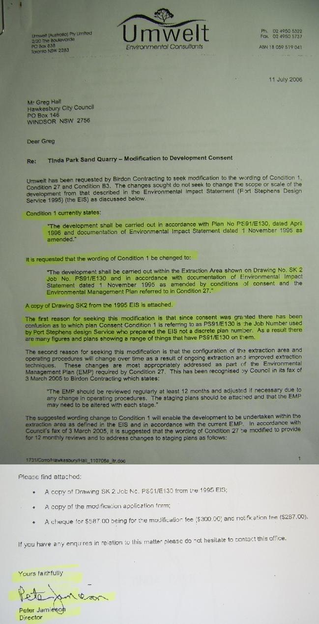
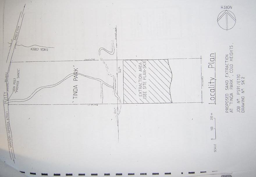
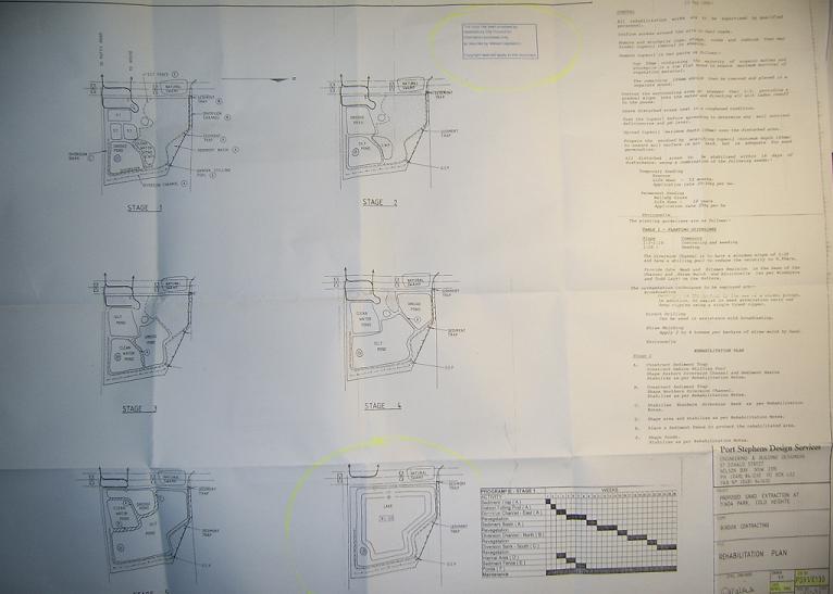
Jamieson then attaches a convenient diagram called "JOB No. PS1/E130 DRAWING No. SK2" which just happens to show a bigger extraction area than the one approved in the detailed actual DA consent with plan from back in 1996 which is "Plan No PS1/E130, dated April 1996". The date is all important as the identifer and Jamieson airbrushes that reality. The bogus SK2 diagram also just happens to truncate the watercourse of Tinda Creek to a mere 100 metres or so from the Singleton/Putty Rd, when in fact it runs all the way to the now sandmine which interrupts the natural watercourse. Here is Jamieson's diagram:
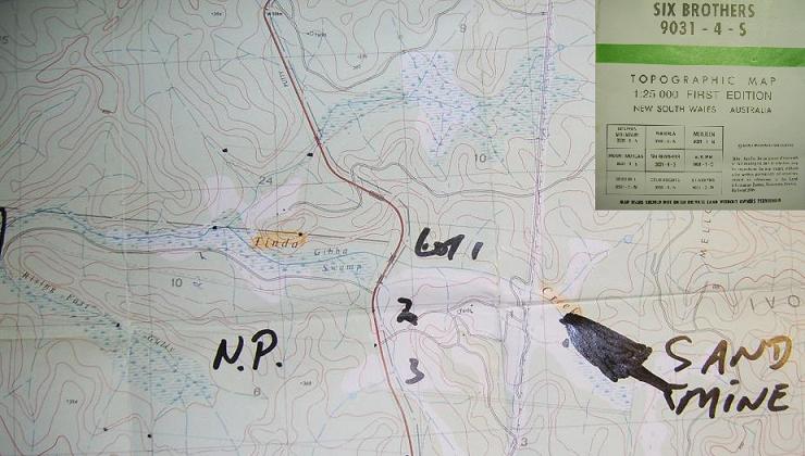
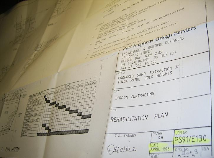
Here are the real approved plans in a set of 1 of 3, 2 of 3 and 3 of 3 from 1996, no confusion, on HCC council file (cost $25) and well known to those who actually follow the planning laws and know about this sandmine saga. This one is no. 2 of 3;
This trick of switching approved plans due to "confusion" via a s.96 application is reminiscent of The Sting movie switching envelopes of cash in broad daylight with untold consequences and so it might be here too.
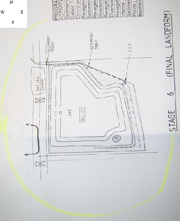
Here is yet another diagram from HCC council report of 29 July 2008 authored by chief planner Matt Owens, a diagram that is not in the s.96 modification application of 2006 by the sandminer as best we can tell:
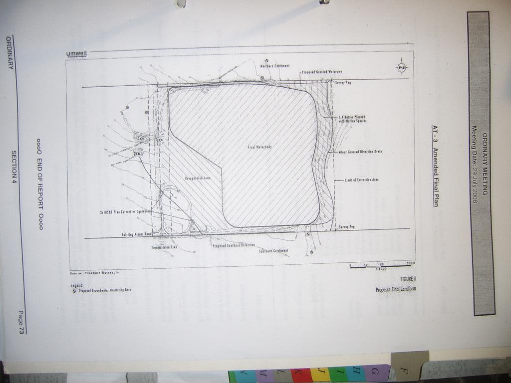
Who generated this diagram? Why is it added to council's report? It may be from the original EIS of 1996 prepared for the developer but as anyone knows the EIS diagrams are not necessarily the approved development subject to all kinds of conditions. Indeed that's the point of environmental impact assessment.
[We are since advised by Neville Diamond that the diagram is from Jamieson/Unwelt for Birdon after the s.96 application of 11 July 2006, as somekind of amendment, but never advertised to the public.]
In any case this diagram adopted by HCC also suggests a much larger 22 ha area of lake final landform extending some 40% into the north east section of the site - 40% out of approved area - not the 15ha that Owens says is the case convenient to the sandminer developer. In independent expert Chris Jewell's report of June 2007 we trust.
Of course it helps the sandminer or any of their barrackers when the quarry is a remote site in a World Heritage precinct set back from the Singleton/Putty road away from prying public eyes - and the only neighbouring land holder knowledgeable enough to say what is going on has been bullied and threatened for 20 years by sandmine staff. Councillors too get a little averse to taking much of an interest in the fine detail when the heavies get involved and the victim starts to rant.
And why are people concerned more broadly now?
This little switch of approved plans is no small thing - the increased area sought in the so called minor change to the existing 1996 development consent, is a whopping 1.3 million tonnes of sand, 40% extension of area. This normally would require a new full Environmental Impact Statement and all the time and expense involved. It is also arguably the difference between 37% water loss to Tinda Ck and to the World Heritage area, already a large volume, and an even higher 53% loss of volume to the World Heritage area.
This is very worrying with the CSIRO noting much greater prevalence of drought and extreme temperatures likely in the future in their July 2008 report:
Minister's media release here:06 Jul 2008 Droughts to be more severe and occur more often in the future
which leads to this:which leads to this a 30 odd page pdf file:
An assessment of the impact of climate change on the nature and frequency of exceptional climatic eventsPDF [2.5mb]
We had trouble downloading in a firefox browser but the explorer browser works well.
Since 1996 the Blue Mountains including Wollemi and Yengo National Parks near the sandmine have now been declared World Heritage areas. Perhaps also for this reason Hawkesbury Council themselves have sought independent expert hydrologist advice in 2007 from Chris Jewell.
And this is what he said as per our correspondence yesterday to the man himself:
Sent: Thursday, October 09, 2008 9:28 PMSubject: attn Chris Jewell re HCC planner Owens divergence with your number re Tinda Ck water lossDear ChrisI write as court agent for Neville Diamond. We attended the information session at HCC when your report was presented in mid 2007.Could you let us know if you stand by the '22 ha lake final landform' area figure mentioned at section 4.1 in second last paragraph to that section on page 11:"If the final landform involved a lake occupying the entire 22-ha operational site, as now proposed, then the reduction in outflow to Tinda Creek would be 204 ML/year, or 53 per cent."We ask because chief planner at HCC has written in his report of July 2008 that"The final landform involves aproximately 15ha"at p45 29 July 2008 HCC business paper. He relies on this to assert the lower water loss rate (still large) of 37% to Tinda Creek applies to the final landform.We will be relying on your report and if you don't want to stand by that evidence it would seem wise to let us know asap. Suffice to say we accept your report on face value as the expert evidence in this matter and your statement.Our reading of the s.96 modification application (Umwelt letter 11 July 2006) with a diagram SK2 (attached) indicates at least to us such an expanded extraction area of 22-ha. Similarly the "Final Waterbody" diagram attached to the HCC report of planner Owens at page 73 also indicates an expanded larger area more like 22 ha rather than 15 ha - at least to us.(By the way we can categorically prove that SK2 was never (contrary to representations in the Unwelt s.96 application) the approved plan diagram when consent was granted way back in 1996. The approved plan was actually identified by job number and date in the original consent as "PS91/E130 dated April 1996". SK2 has the same job number to be sure but there is no ambiguity because it is undated. It is demonstrably not the approved plan in the consent.)(Mr Jamieson of Unwelt, we feel, may need to be consulting his lawyers regarding clause 283 of the EP&A Act Regulation 2000 as regards false and misleading material under the planning regime which is a serious offence.)Please do not hesitate to contact the writer by return email or tel 02-xxxxxxx and 0410 558838.Yours truly, Tom McLoughlin, court agent for Neville Diamond, objector Applicant in Diamond v Birdon Contracting Pty Ltd & Hawkesbury City Council 40733 of 2008.PS You may be interested in these two community news storiesCC Stephen Griffiths, solicitor for HCC6 Oct 08Google Earth reveals illegal drain intercepting Tinda Creek to World Heritage area?
Mood:sharp
Topic: legalSaturday, 4 October 2008Coke Cola juggernaut hits corrugations: Pumping trial and risk continues to 2011
Mood:a-ok
Topic: legal
...................................
ENVIRONMENTAL PLANNING AND ASSESSMENT REGULATION 2000 - REG 283
False or misleading statements
283 False or misleading statements
(cf clause 115 of EP&A Regulation 1994)
"A person is guilty of an offence if the person makes any statement, knowing it to be false or misleading in an important respect, in or in connection with any document lodged with the Director-General or a consent authority or certifying authority for the purposes of the Act or this Regulation. "
...................
And topping off all this is the Federal Court precedent case of the Flying Fox Case:- Judgment granting a final injunction by Branson J: Booth v Bosworth [2001] FCA 1453;
- Judgment granting costs by Branson J: Booth v Bosworth [2001] FCA 1718.
In that case it was impacts from adjacent landholder using an electric grid to fry pesky flying foxes - in their thousands - in breach of the World Heritage Act 1983, here it is killing off a chunk of World Heritage catchment by diverting it's water into a highly evaporative lake from sandmining. Now the 1983 legislation is folded into the Environment Protection and Biodiversity Conservation Act 1999 that protects Cth threatened species and World Heritage areas. Or it should under Federal Minister Peter Garrett's responsibility.
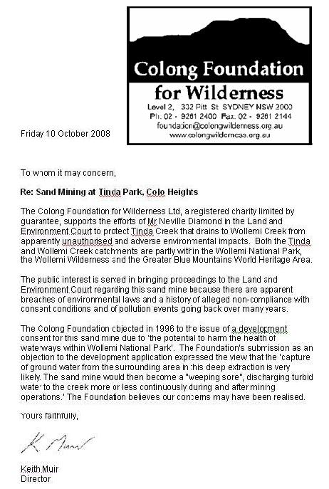
Thanks to Kirsty Ruddock principal solicitor of the EDO for that last legal clarification. And peak green groups are not happy either. The Wilderness Society have written their support and the latest letter is from the well known Blue Mountains defenders Colong Foundation for Wilderness here: